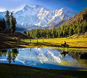
Nanga Parbat
| Nanga Parbat | |
|---|---|

Nanga Parbat, Astore, Gilgit Baltistan, Pakistan
|
|
| Highest point | |
| Elevation | 8,126 m (26,660 ft) Ranked 9th |
| Prominence | 4,608 m (15,118 ft) Ranked 14th |
| Isolation | 189 kilometres (117 mi) |
| Listing |
Eight-thousander Ultra |
| Coordinates | 35°14′15″N 74°35′21″E / 35.23750°N 74.58917°ECoordinates: 35°14′15″N 74°35′21″E / 35.23750°N 74.58917°E |
| Geography | |
| Location |
Gilgit–Baltistan, Pakistan Nanga Parbat lies approx 27km west-southwest of Astore district, in the Gilgit–Baltistan region of Pakistan |
| Parent range | Himalayas |
| Climbing | |
| First ascent | July 3, 1953 by Hermann Buhl (First winter ascent 16 February 2016 by Simone Moro, Alex Txicon & Ali Sadpara) |
| Easiest route | Diamir district (West Face) |
Nanga Parbat (literally in Sanskrit:Naked Mountain ; Urdu: ننگا پربت [nəŋɡaː pərbət̪]) is the ninth highest mountain in the world at 8,126 metres (26,660 ft) above sea level. It is the western anchor of the Himalayas around which the Indus river skirts into the plains of Pakistan. It is located in the Gilgit-Baltistan region of Pakistan and is locally known as 'Deo Mir' ('देओ मीर')('Deo' meaning 'huge') ('mir' meaning 'mountain').
Nanga Parbat is one of the eight-thousanders, with a summit elevation of 8,126 metres (26,660 ft). An immense, dramatic peak rising far above its surrounding terrain, Nanga Parbat is also a notoriously difficult climb. Numerous mountaineering deaths in the mid and early 20th century lent it the nickname "killer mountain".
Nanga Parbat forms the western anchor of the Himalayan Range and is the westernmost eight-thousander. It lies just south of the Indus River in the Diamer District of Gilgit–Baltistan in Pakistan. Not far to the north is the western end of the Karakoram range.
Nanga Parbat has tremendous vertical relief over local terrain in all directions.
To the south, Nanga Parbat boasts what is often referred to as the highest mountain face in the world: the Rupal Face rises 4,600 m (15,090 ft) above its base. To the north, the complex, somewhat more gently sloped Rakhiot Flank rises 7,000 m (22,966 ft) from the Indus River valley to the summit in just 25 km (16 mi), one of the 10 greatest elevation gains in so short a distance on Earth.
...
Wikipedia

