Diamer District
| Diamer District | |
|---|---|
| District | |
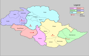
 Map of the Northern Areas of Pakistan, showing the districts and tehsil boundaries. |
|
| Country | Pakistan |
| Capital | Chilas |
| Time zone | PST (UTC+5) |
Diamer District (also called Diamir district ) is one of the nine districts of the Gilgit-Baltistan region of Pakistan. It is the district in which the Karakoram Highway enters that territory from the Khyber Pakhtunkhwa, the capital of the district is Chilas.
Diamer District is bounded by Astore District in the east, by the Khyber Pakhtunkhwa in the southwest (separated by the Babusar Pass or Babusar Top), Neelum District of Azad Kashmir in the south, the Ghizer District in the north and northwest, and the Gilgit District in the north and northeast.
Before the Karakoram Highway was opened in 1978, the only road reaching Gilgit town from the south was a rough track north from Balakot to Babusar Pass (via Kaghan, Naran, Besal, and Gittidas) and further north through Babusar Gah to Chilas. The road up to Besal is now in better condition, but from Besal to Babusar Pass, the road is still a rough track.
According to the Alif Ailaan Pakistan District Education Rankings 2015, Diamer is ranked 95 out of 148 districts in terms of education. For facilities and infrastructure, the district is ranked 127 out of 148.
...
Wikipedia
