NC 43
| North Carolina Highway 43 | ||||
|---|---|---|---|---|

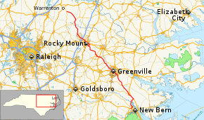
Route of NC 43 highlighted in red
|
||||
| Route information | ||||
| Maintained by NCDOT | ||||
| Length: | 119.6 mi (192.5 km) | |||
| Existed: | 1928 – present | |||
| Major junctions | ||||
| South end: |
|
|||
|
|
||||
| North end: |
|
|||
| Location | ||||
| Counties: | Craven, Pitt, Edgecombe, Nash, Halifax, Warren | |||
| Highway system | ||||
|
||||
|
North Carolina Highway 43 Business |
|
|---|---|
| Location: | Rocky Mount, North Carolina |
| Length: | 5.0 mi (8.0 km) |
| Existed: | 2001–present |
North Carolina Highway 43 (NC 43) is a 120-mile-long (190 km) state highway in North Carolina. It connects many towns in the Coastal Plain region.
NC 43 was established around 1928 as a new primary routing between US 17-1/NC 40, in Rocky Mount, and NC 58, in Liberia. In 1931, NC 43 was extended southeast on new primary routing, through Pinetops, to Greenville; then replaced NC 301 to US 17/NC 30, in Vanceboro. Around 1936, NC 43 was rerouted onto new roadway at Essex, avoiding Hollister. In 1958, NC 43 was rerouted in the downtown Greenville area, leaving behind: Charles Avenue, 10th Street, Albemarle Street and 5th Street.
In 1987, NC 43 was extended south of Vanceboro along US 17 Bus. and US 17 to Weyerhaeuser Road. Traveling along Weyerhaeuser Road, it connects and overlap with NC 55 going into New Bern; then with US 70 Bus. and southward to US 70 and US 17. The resulting new routing made a western rural bypass of New Bern. In 1998, NC 43 was rerouted onto new connector in downtown Rocky Mount. In 2001, NC 43 was rerouted onto northern bypass route around Rocky Mount, leaving behind NC 43 Bus. In 2009, NC 43 was rerouted onto new road between NC 55 and US 17/US 70, eliminating its routing through New Bern.
...
Wikipedia

