Pitt County, North Carolina
| Pitt County, North Carolina | ||
|---|---|---|

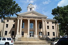
Pitt County Courthouse in Greenville
|
||
|
||
 Location in the U.S. state of North Carolina |
||
 North Carolina's location in the U.S. |
||
| Founded | 1760 | |
| Named for | William Pitt the Elder | |
| Seat | Greenville | |
| Largest city | Greenville | |
| Area | ||
| • Total | 655 sq mi (1,696 km2) | |
| • Land | 652 sq mi (1,689 km2) | |
| • Water | 2.9 sq mi (8 km2), 0.4% | |
| Population (est.) | ||
| • (2013) | 174,263 | |
| • Density | 258/sq mi (100/km²) | |
| Congressional districts | 1st, 3rd | |
| Time zone | Eastern: UTC-5/-4 | |
| Website | www |
|
Pitt County is a county located in the U.S. state of North Carolina. As of the 2010 census, the population was 168,148. Its county seat is Greenville.
Pitt County comprises the Greenville, NC Metropolitan Statistical Area. As one of the fastest growing centers in the state, the county has seen a population boom since 1990.
The county was formed in 1760 from Beaufort County, though the legislative act that created it did not become effective until January 1, 1761. It was named for William Pitt the Elder, who was then Secretary of State for the Southern Department and Leader of the House of Commons. William Pitt was an English statesman and orator, born in London, England. He studied at Oxford University and in 1731 joined the army. Pitt led the young "Patriot" Whigs and in 1756 became secretary of state, where he was a pro-freedom speaker in British Colonial government.
According to the U.S. Census Bureau, the county has a total area of 655 square miles (1,700 km2), of which 652 square miles (1,690 km2) is land and 2.9 square miles (7.5 km2) (0.4%) is water.
As of the census of 2000, there were 133,798 people, 52,539 households, and 32,258 families residing in the county. The population density was 205 people per square mile (79/km²). There were 58,408 housing units at an average density of 90 per square mile (35/km²). The racial makeup of the county was 62.08% White, 33.65% Black or African American, 0.27% Native American, 1.08% Asian, 0.04% Pacific Islander, 1.80% from other races, and 1.09% from two or more races. 3.15% of the population were Hispanic or Latino of any race.
...
Wikipedia

