Mountrail County, North Dakota
| Mountrail County, North Dakota | |
|---|---|

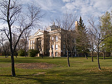
Mountrail County Courthouse in Stanley
|
|
 Location in the U.S. state of North Dakota |
|
 North Dakota's location in the U.S. |
|
| Founded | January 4, 1873 1892 (eliminated) January 29, 1909 (reestablished) |
| Seat | Stanley |
| Largest city | Stanley |
| Area | |
| • Total | 1,942 sq mi (5,030 km2) |
| • Land | 1,825 sq mi (4,727 km2) |
| • Water | 116 sq mi (300 km2), 6.0% |
| Population (est.) | |
| • (2015) | 10,331 |
| • Density | 4.2/sq mi (2/km²) |
| Congressional district | At-large |
| Time zone | Central: UTC-6/-5 |
| Website | www |
Mountrail County is a county located in the northwestern part of North Dakota, United States. As of the 2010 census, the population was 7,673. Its county seat is Stanley. The county was originally created in 1873, then removed in 1892, annexed by Ward County. It was re-created and organized in 1909.
Oil production from the Bakken formation in the early 21st century has attracted workers and reversed decades of population decline in the county. From 2010 to 2015, especially, population has markedly increased, creating its own strains.
Mountrail County was first established in 1873 (as Mountraille County) by the Dakota Territorial Legislature. The boundaries extended from the Missouri River north to the border with Canada. It remained a county when North Dakota became a state in 1889, but in 1892 North Dakota Legislature authorized neighboring Ward County to take over all of Mountrail's territory, and this county was eliminated.
At the November 3, 1908, general election, a vote was held in Ward County on whether to recreate Mountrail with different boundaries. The vote was 4,207 to 4,024 in favor of the new county, but North Dakota's Attorney General sued the Secretary of State over the validity of the vote. Organization of the new Mountrail County was delayed until the Supreme Court affirmed the vote in January 1909.
According to the U.S. Census Bureau, the county has a total area of 1,942 square miles (5,030 km2), of which 1,825 square miles (4,730 km2) is land and 116 square miles (300 km2) (6.0%) is water.
...
Wikipedia
