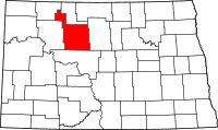
Ward County, North Dakota
| Ward County, North Dakota | |
|---|---|
 Location in the U.S. state of North Dakota |
|
 North Dakota's location in the U.S. |
|
| Founded | November 23, 1885 |
| Seat | Minot |
| Largest city | Minot |
| Area | |
| • Total | 2,056 sq mi (5,325 km2) |
| • Land | 2,013 sq mi (5,214 km2) |
| • Water | 43 sq mi (111 km2), 2.1% |
| Population (est.) | |
| • (2015) | 71,275 |
| • Density | 31/sq mi (12/km²) |
| Congressional district | At-large |
| Time zone | Central: UTC-6/-5 |
| Website | www |
Ward County is a county located in the U.S. state of North Dakota. As of the 2010 census, the population was 61,675, making it the third-most populous county in North Dakota. Its county seat is Minot. The county was formed in 1885.
Ward County is part of the Minot, ND Micropolitan Statistical Area.
Ward County was created by the 1885 Dakota Territory legislature and named for Mark Ward, chairman of the House of Representatives Committee on Counties during the session. The county government was first organized on November 23, 1885 with Burlington as the county seat. This was changed to Minot in 1888.
Until 1908, Ward County included what is now Burke, Mountrail, and Renville counties; this landmass often being referred to as 'Imperial Ward' County and which was the largest county in the state at the time. In 1908, voters took up measures to partition the county. The results for that portion forming Mountrail County were accepted but a dispute over the results for the portions that would become Burke and Renville counties was taken to court and which resulted in favorable rulings in 1910. In addition, when the proposed county lines for Burke and Renville counties were drawn, neither group wanted to include Kenmare and risk that city becoming the county seat, so Kenmare was left in Ward County at the end of a narrow strip of land, commonly referred to as the 'gooseneck'.
According to the U.S. Census Bureau, the county has a total area of 2,056 square miles (5,330 km2), of which 2,013 square miles (5,210 km2) is land and 43 square miles (110 km2) (2.1%) is water. It is the fifth-largest county in North Dakota by land area.
...
Wikipedia
