Montgomery County, NC
| Montgomery County, North Carolina | ||
|---|---|---|

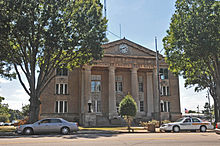
Montgomery County Courthouse
|
||
|
||
| Motto: The Golden Opportunity | ||
 Location in the U.S. state of North Carolina |
||
 North Carolina's location in the U.S. |
||
| Founded | 1779 | |
| Named for | Richard Montgomery | |
| Seat | Troy | |
| Largest town | Troy | |
| Area | ||
| • Total | 502 sq mi (1,300 km2) | |
| • Land | 492 sq mi (1,274 km2) | |
| • Water | 10 sq mi (26 km2), 2.0% | |
| Population | ||
| • (2010) | 27,798 | |
| • Density | 57/sq mi (22/km²) | |
| Congressional district | 8th | |
| Time zone | Eastern: UTC-5/-4 | |
| Website | www |
|
Montgomery County is a rural county located in the U.S. state of North Carolina. As of the 2010 census, the population was 27,798. Its county seat is Troy.
Montgomery County's motto is "The Golden Opportunity".
The county was formed in 1779 from Anson County. It was named in honor and respect of Richard Montgomery, an American Revolutionary War general killed in 1775 while attempting to capture Quebec City, Canada. In 1841 the part of Montgomery County west of the Pee Dee River became Stanly County
According to the U.S. Census Bureau, the county has a total area of 502 square miles (1,300 km2), of which 492 square miles (1,270 km2) is land and 10 square miles (26 km2) (2.0%) is water. It is situated in the heart of the Uwharrie National Forest. There are also schools in Montgomery County such as Star Elementary, Mt. Gilead Elementary, Candor Elementary, Page Street Elementary, Green Ridge Elementary, West Montgomery Middle, East Montgomery Middle, East Montgomery High, and West Montgomery High.
As of the census of 2000, there were 26,822 people, 9,848 households, and 7,189 families residing in the county. The population density was 55 people per square mile (21/km²). There were 14,145 housing units at an average density of 29 per square mile (11/km²). The racial makeup of the county was 69.07% White, 21.84% Black or African American, 0.40% Native American, 1.61% Asian, 0.04% Pacific Islander, 5.75% from other races, and 1.29% from two or more races. 10.43% of the population were Hispanic or Latino of any race.
...
Wikipedia

