Troy, North Carolina
| Troy, North Carolina | |
|---|---|
| Town | |

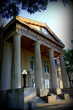
Montgomery County Courthouse, June 2014
|
|
| Motto: "Gateway to the Uwharries" | |
 Location of Troy, North Carolina |
|
| Coordinates: 35°21′38″N 79°53′47″W / 35.36056°N 79.89639°WCoordinates: 35°21′38″N 79°53′47″W / 35.36056°N 79.89639°W | |
| Country | United States |
| State | North Carolina |
| County | Montgomery |
| Area | |
| • Total | 3.0 sq mi (7.7 km2) |
| • Land | 3.0 sq mi (7.7 km2) |
| • Water | 0.0 sq mi (0.0 km2) |
| Elevation | 659 ft (201 m) |
| Population (2010) | |
| • Total | 3,189 |
| • Density | 1,063/sq mi (414.1/km2) |
| Time zone | Eastern (EST) (UTC-5) |
| • Summer (DST) | EDT (UTC-4) |
| ZIP code | 27371 |
| Area code(s) | 910 |
| FIPS code | 37-68520 |
| GNIS feature ID | 1024364 |
Troy is a town in Montgomery County, North Carolina, United States. The population was 3,189 at the 2010 census. It is the county seat of Montgomery County. The short story by Charles W. Chesnutt, called "The Sheriff's Children," is set in Troy
The Hotel Troy, Montgomery County Courthouse, and Troy Residential Historic District are listed on the National Register of Historic Places.
Troy is located at 35°21′38″N 79°53′47″W / 35.36056°N 79.89639°W (35.360420, -79.896412).
According to the United States Census Bureau, the town has a total area of 3.0 square miles (7.8 km2), of which, 3.0 square miles (7.8 km2) of it is land and 0.34% is water.
As of the census of 2000, there were 3,430 people, 1,108 households, and 710 families residing in the town. The population density was 1,156.8 people per square mile (445.9/km²). There were 1,209 housing units at an average density of 407.7 per square mile (157.2/km²). The racial makeup of the town was 54.43% White, 38.98% African American, 0.73% Native American, 1.14% Asian, 3.32% from other races, and 1.40% from two or more races. Hispanic or Latino of any race were 7.23% of the population.
...
Wikipedia
