Monongahela Valley
| Monongahela River | |
|
The Monongahela River in Pittsburgh passing the South Side on the right and Uptown/The Bluff on the left just before entering Downtown Pittsburgh
|
|
| Country | United States |
|---|---|
| States | Pennsylvania, West Virginia |
| Counties | Marion WV, Monongalia WV, Greene PA, Fayette PA, Washington PA, Westmoreland PA, Allegheny PA |
| Tributaries | |
| - left | Peters Creek, Streets Run, Becks Run |
| - right | Cheat River, Youghiogheny River, Turtle Creek |
| Source | Tygart Valley River |
| - location | Pocahontas County, West Virginia |
| - elevation | 4,540 ft (1,384 m) |
| - coordinates | 38°28′06″N 79°58′51″W / 38.46833°N 79.98083°W |
| Secondary source | West Fork River |
| - location | Upshur County, West Virginia |
| - elevation | 1,309 ft (399 m) |
| - coordinates | 38°51′08″N 80°21′32″W / 38.85222°N 80.35889°W |
| Source confluence | |
| - location | Fairmont, West Virginia |
| - elevation | 863 ft (263 m) |
| - coordinates | 39°27′53″N 80°09′10″W / 39.46472°N 80.15278°W |
| Mouth | Ohio River |
| - location | Pittsburgh, Pennsylvania |
| - elevation | 709 ft (216 m) |
| - coordinates | 40°26′30″N 80°00′58″W / 40.44167°N 80.01611°WCoordinates: 40°26′30″N 80°00′58″W / 40.44167°N 80.01611°W |
| Length | 130 mi (209 km) |
| Basin | 7,340 sq mi (19,011 km2) |
| Discharge | for Braddock, PA |
| - average | 12,650 cu ft/s (358 m3/s) |
| - max | 81,100 cu ft/s (2,296 m3/s) |
| - min | 2,900 cu ft/s (82 m3/s) |
| Discharge elsewhere (average) | |
| - Masontown, PA | 8,433 cu ft/s (239 m3/s) |
|
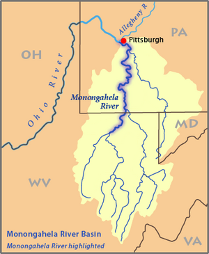
Map of the Monongahela River basin, with the Monongahela River highlighted
|
|
The Monongahela River (/məˌnɒnɡəˈhiːlə/) — often referred to locally as the Mon /ˈmɒn/ — is a 130-mile-long (210 km)river on the Allegheny Plateau in north-central West Virginia and southwestern Pennsylvania, which flows from south to north. The Monongahela joins the Allegheny River to form the Ohio River at Pittsburgh.
The Native American word Monongahela means "falling banks", in reference to the geological instability of the river's banks. Moravian missionary David Zeisberger (1721–1808) gave this account of the naming: "In the Indian tongue the name of this river was Mechmenawungihilla (alternatively spelled Menawngihella), which signifies a high bank, which is ever washed out and therefore collapses."
The Lenape Language Project renders the word as Mënaonkihëla (pronounced [mənaoŋɡihəla]), translated "where banks cave in or erode", from the verbs mënaonkihële "the dirt caves off" (such as the bank of a river or creek, or in a landslide) and mënaonke (pronounced [mənaoŋɡe]), "it has a loose bank" (where one might fall in).
...
Wikipedia


