Tygart Valley River
| Tygart Valley River | |
|
The Tygart Valley River at the mouth of the Buckhannon River (just above center). Photo taken along the B&O Railroad between Belington and Philippi.
|
|
| Country | United States |
|---|---|
| State | West Virginia |
| Counties | Barbour, Marion, Pocahontas, Taylor, Randolph |
| Tributaries | |
| - left | Middle Fork River, Buckhannon River |
| Source | Allegheny Mountains |
| - location | Pocahontas County, WV |
| - elevation | 4,540 ft (1,384 m) |
| - coordinates | 38°28′06″N 79°58′51″W / 38.46833°N 79.98083°W |
| Mouth | Monongahela River |
| - location | Fairmont, WV |
| - elevation | 863 ft (263 m) |
| - coordinates | 39°27′54″N 80°09′11″W / 39.46500°N 80.15306°WCoordinates: 39°27′54″N 80°09′11″W / 39.46500°N 80.15306°W |
| Length | 135 mi (217 km) |
| Basin | 1,329 sq mi (3,442 km2) |
| Discharge | for Philippi, WV |
| - average | 1,922 cu ft/s (54 m3/s) |
| - max | 61,000 cu ft/s (1,727 m3/s) |
| - min | 4.9 cu ft/s (0 m3/s) |
| Discharge elsewhere (average) | |
| - near Dailey, WV | 358 cu ft/s (10 m3/s) |
|
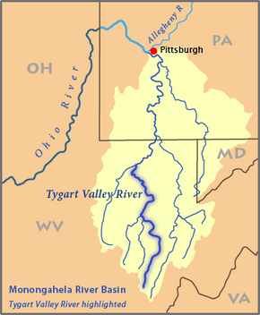
Map of the Monongahela River basin, with the Tygart Valley River highlighted
|
|
The Tygart Valley River — also known as the Tygart River — is a principal tributary of the Monongahela River, approximately 135 miles (217 km) long, in east-central West Virginia in the United States. Via the Monongahela and Ohio rivers, it is part of the watershed of the Mississippi River, draining an area of 1,329 square miles (3,440 km2) in the Allegheny Mountains and the unglaciated portion of the Allegheny Plateau.
The Tygart Valley River rises in the Allegheny Mountains in Pocahontas County and flows generally north-northwestwardly through Randolph, Barbour, Taylor and Marion counties, past the towns of Huttonsville, Mill Creek, Beverly, Elkins, Junior, Belington, Philippi, Arden, and Grafton, to Fairmont, where it joins the West Fork River to form the Monongahela River. Downstream of Elkins, the Tygart Valley River passes through a gap between Rich Mountain and Laurel Mountain, which are considered to be part of the westernmost ridge of the Allegheny Mountains and the boundary between the Alleghenies and the Allegheny Plateau.
...
Wikipedia


