Laurel Mountain (West Virginia)
| Laurel Mountain, West Virginia | |
|---|---|
 |
|
| Highest point | |
| Elevation | 3,157 ft (962 m) |
| Coordinates | 39°08′32″N 79°50′0″W / 39.14222°N 79.83333°WCoordinates: 39°08′32″N 79°50′0″W / 39.14222°N 79.83333°W |
| Geography | |
| Location | West Virginia, U.S. |
| Parent range | Allegheny Mountains, part of the Ridge-and-Valley Appalachians |
| Topo map | USGS Colebank |
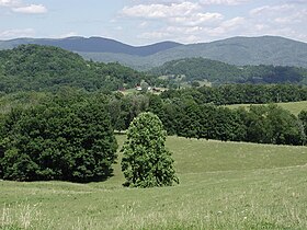
Laurel Mountain, also called Laurel Hill, is a long ridge in north-central West Virginia, US. Along with Rich Mountain to the south, it is considered to be the westernmost ridge of the Allegheny Mountains and the boundary between the Alleghenies and the Allegheny Plateau.
Running northeast to southwest through Preston, Tucker, Barbour, and Randolph Counties, the ridge forms portions of the borders between them. It stretches for about 32 miles (51 km) from the Cheat River (near the town of Manheim) in the north to the Tygart Valley River (near the town of Aggregates) in the south. It achieves its highest elevation at the Eliot Benchmark (3,157 ft/962 m) about 3.5 miles (5.6 km) north of Pleasure Valley.
The mountain is formed by the same structural fold in the Earth's crust which continues north from Laurel as Briery Mountains (north of Cheat River) and south as Rich Mountain (south of the Tygart Valley River). The mountain is characteristic of the long, folded mountains of the Appalachian Valley and Ridge Region and is located at the western edge of that physiographic province.
Laurel Mountain's name was derived from the prolific "great laurel" (Rhododendron maximum) which the earliest pioneers found there in profusion the late 1700s.
...
Wikipedia
