Cheat River
| Cheat River | |
|
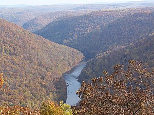
The Cheat River Gorge, as viewed from Cooper's Rock Overlook
|
|
| Country | United States |
|---|---|
| States | Pennsylvania, West Virginia |
| County | Fayette PA, Monongalia WV, Preston WV, Tucker WV |
| Tributaries | |
| - right | Big Sandy Creek |
| Source | Shavers Fork |
| - elevation | 4,620 ft (1,408 m) |
| - coordinates | 38°23′50″N 79°59′09″W / 38.39722°N 79.98583°W |
| Secondary source | Black Fork |
| - location | Hendricks, West Virginia |
| - elevation | 1,700 ft (518 m) |
| - coordinates | 39°04′20″N 79°37′45″W / 39.07222°N 79.62917°W |
| Source confluence | |
| - location | Parsons, WV |
| - elevation | 1,621 ft (494 m) |
| - coordinates | 39°07′01″N 79°40′51″W / 39.11694°N 79.68083°W |
| Mouth | Monongahela River |
| - location | Point Marion, PA |
| - elevation | 760 ft (232 m) |
| - coordinates | 39°44′34″N 79°54′08″W / 39.74278°N 79.90222°WCoordinates: 39°44′34″N 79°54′08″W / 39.74278°N 79.90222°W |
| Length | 78 mi (126 km) |
| Basin | 1,423 sq mi (3,686 km2) |
| Discharge | for Rowlesburg, WV |
| - average | 3,880 cu ft/s (110 m3/s) |
| - max | 53,400 cu ft/s (1,512 m3/s) |
| - min | 908 cu ft/s (26 m3/s) |
| Discharge elsewhere (average) | |
| - Parsons, WV | 3,700 cu ft/s (105 m3/s) |
|
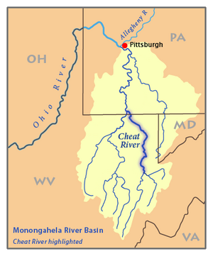
Map of the Monongahela River basin, with the Cheat River highlighted.
|
|
The Cheat River is a 78.3-mile-long (126.0 km)tributary of the Monongahela River in eastern West Virginia and southwestern Pennsylvania in the United States. Via the Ohio River, the Cheat and Monongahela are part of the Mississippi River watershed. Owing to the ruggedness of the Allegheny Mountains, a portion of which it drains, the Cheat remains largely remote with few settlements or developments along its banks. Its headwaters are in the Cheat-Potomac Ranger District of the Monongahela National Forest.
The Cheat is formed at Parsons, West Virginia, by the confluence of Shavers Fork and Black Fork. Black Fork is fed by the Blackwater River and by the Dry, Glady, and Laurel Forks — these are traditionally referred to as the five Forks of Cheat. (The "High Falls of Cheat" [15 feet/4.6 m high] is a few miles upstream of Bemis on Shavers Fork.) From Parsons the Cheat River flows generally northward through Tucker and Preston counties, past the towns of Rowlesburg and Albright. It then flows through an impressive gorge — Cheat Canyon — northeastwardly from Albright, collecting Big Sandy Creek before entering Monongalia County, where a hydro-electric dam just south of the Pennsylvania border causes it to widen as the Cheat Lake reservoir. It then flows for a short distance through southwestern Fayette County, Pennsylvania, before joining the Monongahela River at Point Marion, Pennsylvania. Upstream of its dam, the Cheat is one of the largest undammed watersheds in the eastern United States.
...
Wikipedia


