Moggio Udinese
| Moggio Udinese | |
|---|---|
| Comune | |
| Comune di Moggio Udinese | |

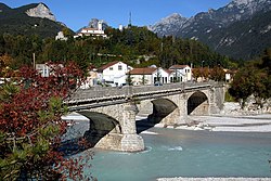
Bridge across the Fella River with San Gallo Abbey
|
|
| Location of Moggio Udinese in Italy | |
| Coordinates: 46°25′N 13°12′E / 46.417°N 13.200°ECoordinates: 46°25′N 13°12′E / 46.417°N 13.200°E | |
| Country | Italy |
| Region | Friuli-Venezia Giulia |
| Province / Metropolitan city | Udine (UD) |
| Frazioni | Bevorchians, Campiolo, Dordolla, Grauzaria, Moggessa, Monticello, Ovedasso, Pradis-Chiaranda, Stavoli |
| Government | |
| • Mayor | Giorgio Filaferro |
| Area | |
| • Total | 143.5 km2 (55.4 sq mi) |
| Elevation | 341 m (1,119 ft) |
| Population (1 January 2016) | |
| • Total | 1,745 |
| • Density | 12/km2 (31/sq mi) |
| Demonym(s) | Moggesi |
| Time zone | CET (UTC+1) |
| • Summer (DST) | CEST (UTC+2) |
| Postal code | 33015 |
| Dialing code | 0433 |
| Website | Official website |
Moggio Udinese (Friulian: Mueç, German: Moosach, Slovene: Možac) is a comune (municipality) in the Province of Udine in the Italian region Friuli-Venezia Giulia.
It is situated in the Friuli region, in the valley of the Fella River, a right tributary of the Tagliamento. Moggio is located about 100 kilometres (62 mi) northwest of Trieste and about 40 kilometres (25 mi) north of Udine. In the north, the mountains of the Carnic Alps stretch up to the border with Austria; beyond the Fella are the Julian Alps with the Resia Valley in the southeast. As of 31 December 2004, the municipality had a population of 1,991 and an area of 143.5 square kilometres (55.4 sq mi). It can be reached via the Autostrada A23.
Moggio Udinese borders the following municipalities: Amaro, Arta Terme, Chiusaforte, Dogna, Hermagor-Pressegger See (Austria), Paularo, Pontebba, Resiutta, Tolmezzo, Venzone.
The area had already been settled in Roman times, when a castrum or at least a watchtower was erected to control the traffic on the road from Italy to the province of Noricum in the north.
...
Wikipedia

