Hermagor-Pressegger See
| Hermagor-Pressegger See | ||
|---|---|---|

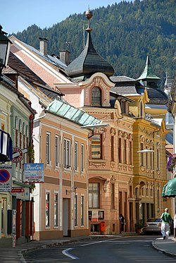
Town centre
|
||
|
||
| Location within Austria | ||
| Coordinates: 46°37′38″N 13°22′02″E / 46.62722°N 13.36722°ECoordinates: 46°37′38″N 13°22′02″E / 46.62722°N 13.36722°E | ||
| Country | Austria | |
| State | Carinthia | |
| District | Hermagor | |
| Government | ||
| • Mayor | Siegfried Ronacher (SPÖ) | |
| Area | ||
| • Total | 204.84 km2 (79.09 sq mi) | |
| Elevation | 602 m (1,975 ft) | |
| Population (1 January 2016) | ||
| • Total | 6,840 | |
| • Density | 33/km2 (86/sq mi) | |
| Time zone | CET (UTC+1) | |
| • Summer (DST) | CEST (UTC+2) | |
| Postal code | 9620 | |
| Area codes | 0 42 82 | |
| Vehicle registration | HE | |
| Website | www.hermagor.at | |
Hermagor-Pressegger See (Slovene: Šmohor-Preseško jezero) is a town in the Austrian state of Carinthia. It is the administrative centre of Hermagor District. The town is named after Saint Hermagoras, the first bishop of Aquileia.
Hermagor is located in the lower Gail valley at the northern foot of the Carnic Alps, close to the border with Italy. In the south, the Naßfeld Pass connects it with the Italian municipality of Pontebba. In the north, the road leads via Gitschtal into the Gailtal Alps, across Kreuzberg Saddle to the Weissensee lake and further down to Greifenburg in the Drava valley. Hermagor station is a stop on the Gailtal Railway line from Arnoldstein to Kötschach-Mauthen.
The municipal area comprises shallow Pressegger See, one of the warmest lakes in Austria with extensive reed banks.
Hermagor-Pressegger See is divided into the following cadastral communities:
It is further divided into the following settlements: Achleiten (4), Aigen (4), Bergl (24), Braunitzen (12) (Boronica), Brugg (31) (Moste), Burgstall (9), Danz (26), Dellach (94) (Dole), Egg (178) (Brdo), Eggforst (10), Förolach (162), Fritzendorf (58) (Limarče), Görtschach (173), Götzing (22) (Gocina), Grafenau (0) (Kazla), Grünburg (70), Guggenberg (34), Hermagor (1.527) (Šmohor), Jenig (178) (Jenik), Kameritsch (80) (Kamerče), Khünburg (247), Kleinbergl (30), Kraß (14), Kraschach (57) (Krošani), Kreuth ob Möschach (19) (Rut(e)), Kreuth ob Mellweg (60) (Rut(e)), Kreuth ob Rattendorf (76) (Rute(e)), Kühweg (202), Kühwegboden (156), Latschach (86) (Loče), Liesch (7), Möderndorf (223) (Modrinja vas/ves), Mellach (49) (Mele), Mellweg (45) (Melviče, Maloviše), Micheldorf (167) (Velika vas/ves), Mitschig (79) (Mičiče), Nampolach (27) (Napole), Neudorf (271), Neuprießenegg (36), Obermöschach (38), Obervellach (243), Paßriach (143)(Pažirje), Podlanig (51) (Podlanig), Postran (123) (Postran), Potschach (61) (Potoče), Presseggen (222) (Preseka), Presseggersee (130) (Preseško jezero), Radnig (203), Radnigforst (0), Rattendorf (343) (Radnja vas), Schinzengraben (26), Schlanitzen (41) (Zelenica), Schmidt (1), Siebenbrünn (2), Sonnenalpe Naßfeld (27)(Mokrine), Sonnleitn (17), Süßenberg (20) (Planja), Toschehof (0) (Tesinje), Tröpolach (535) (Dobropolje, Dropolje), Untermöschach (48), Untervellach (229), Watschig (129) (Vočiče), Wittenig (50), Zuchen (3) (Suha).
...
Wikipedia


