Kötschach-Mauthen
| Kötschach-Mauthen | ||
|---|---|---|

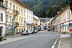
Main street in Mauthen
|
||
|
||
| Location within Austria | ||
| Coordinates: 46°40′N 13°0′E / 46.667°N 13.000°ECoordinates: 46°40′N 13°0′E / 46.667°N 13.000°E | ||
| Country | Austria | |
| State | Carinthia | |
| District | Hermagor | |
| Government | ||
| • Mayor | Walter Hartlieb | |
| Area | ||
| • Total | 154.48 km2 (59.65 sq mi) | |
| Elevation | 705 m (2,313 ft) | |
| Population (1 January 2016) | ||
| • Total | 3,459 | |
| • Density | 22/km2 (58/sq mi) | |
| Time zone | CET (UTC+1) | |
| • Summer (DST) | CEST (UTC+2) | |
| Postal code | 9640 | |
| Area codes | 2 03 07 | |
| Website | www.koetschach-mauthen.at | |
Kötschach-Mauthen (Slovene: Koča-Muta) is a market town in the district of Hermagor in Carinthia in Austria.
The municipality lies 34 km (21 mi) in the west of Hermagor at the transition of the upper Gail Valley into the Lesachtal, between the Gailtal and Carnic Alps. It is located at an important road junction: in the north, the highway leads up to Gailberg Saddle and the market town of Oberdrauburg, in the south to Plöcken Pass on the Carinthian border with the Carnian region of Friuli, Italy.
Kötschach-Mauthen is divided into the four municipalities Kötschach (Koče), Mauthen (Muta), Strajach (Srejah), and Würmlach (Bumlje). It covers 31 localities (in parentheses number of inhabitants according to the 2001 population census):
According to the 2001 population census Kötschach-Mauthen has 3.613 inhabitants. 95,0% of its inhabitants are Austrian, 1,2% German and 0,9% Turkish citizens. 89,1% of the population are Roman-Catholic, 6,6% Protestant and 1,3% are Muslim. 1,8% of the population are without any religious confession.
The area in the Gail Valley was already settled around 200 BC. A Venetian rock inscription from this time still exists today in Würmlach. A Roman road ran over Plöcken Pass and led to the Noricum province, where a mansio named Loncium stood above present-day Mauthen (derived from German: Maut, "toll").
...
Wikipedia


