Missouri river
| Missouri River | |
| Pekitanoui, Big Muddy, Mighty Mo, Wide Missouri, Kícpaarukstiʾ, Lakota: Mnišoše | |
|
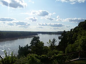
A relatively undeveloped reach of the river near Rocheport, Missouri
|
|
| Name origin: The Missouri tribe, whose name in turn meant "people with wooden canoes" | |
| Country | United States |
|---|---|
| States | Montana, North Dakota, South Dakota, Nebraska, Iowa, Kansas, Missouri |
| Tributaries | |
| - left | Jefferson, Dearborn, Sun, Marias, Milk, James, Big Sioux, Grand, Chariton |
| - right | Madison, Gallatin, Yellowstone, Little Missouri, Cheyenne, White, Niobrara, Platte, Kansas, Osage, Gasconade |
| Cities | Great Falls, MT, Bismarck, ND, Pierre, SD, Sioux City, IA, Omaha, NE, Kansas City, KS, Kansas City, MO, St. Louis, MO |
| Primary source | Hell Roaring Creek, a tributary of the Jefferson River |
| - location | near Brower's Spring, Montana |
| - elevation | 9,100 ft (2,774 m) |
| - coordinates | 44°32′31″N 111°27′53″W / 44.54194°N 111.46472°W |
| Secondary source | Firehole River, a tributary of the Madison River |
| - location | Madison Lake, Yellowstone National Park, Wyoming |
| - elevation | 8,215 ft (2,504 m) |
| - coordinates | 44°20′55″N 110°51′53″W / 44.34861°N 110.86472°W |
| Source confluence | Missouri Headwaters State Park |
| - location | Three Forks, Montana |
| - elevation | 4,042 ft (1,232 m) |
| - coordinates | 45°55′39″N 111°20′39″W / 45.92750°N 111.34417°W |
| Mouth | Mississippi River |
| - location | Spanish Lake, near St. Louis, Missouri |
| - elevation | 404 ft (123 m) |
| - coordinates | 38°48′49″N 90°07′11″W / 38.81361°N 90.11972°WCoordinates: 38°48′49″N 90°07′11″W / 38.81361°N 90.11972°W |
| Length | 2,341 mi (3,767 km) |
| Basin | 529,350 sq mi (1,371,010 km2) |
| Discharge | for Hermann, MO; RM 97.9 (RKM 157.6) |
| - average | 87,520 cu ft/s (2,478 m3/s) |
| - max | 750,000 cu ft/s (21,238 m3/s) |
| - min | 602 cu ft/s (17 m3/s) |
|
Map of the Missouri River and its tributaries in
North America |
|
The Missouri River is the longest river in North America. Rising in the Rocky Mountains of western Montana, the Missouri flows east and south for 2,341 miles (3,767 km) before entering the Mississippi River north of St. Louis, Missouri. The river takes drainage from a sparsely populated, semi-arid watershed of more than half a million square miles (1,300,000 km2), which includes parts of ten U.S. states and two Canadian provinces. When combined with the lower Mississippi River, it forms the world's fourth longest river system.
For over 12,000 years, people have depended on the Missouri River and its tributaries as a source of sustenance and transportation. More than ten major groups of Native Americans populated the watershed, most leading a nomadic lifestyle and dependent on enormous bison herds that once roamed through the Great Plains. The first Europeans encountered the river in the late seventeenth century, and the region passed through Spanish and French hands before finally becoming part of the United States through the Louisiana Purchase. The Missouri was long believed to be part of the Northwest Passage – a water route from the Atlantic to the Pacific – but when Lewis and Clark became the first to travel the river's entire length, they confirmed the mythical pathway to be no more than a legend.
The Missouri River was one of the main routes for the westward expansion of the United States during the 19th century. The growth of the fur trade in the early 1800s laid much of the groundwork as trappers explored the region and blazed trails. Pioneers headed west en masse beginning in the 1830s, first by covered wagon, then by the growing numbers of steamboats entering service on the river. Former Native American lands in the watershed were taken over by settlers, leading to some of the most longstanding and violent wars against indigenous peoples in American history.
...
Wikipedia


