Platte River
| Platte River | |
| Nebraska River, Shallow River | |
|
Platte River at Mahoney State Park
|
|
| Country | United States |
|---|---|
| State | Nebraska |
| Region | Great Plains |
| Part of | Missouri River basin |
| Tributaries | |
| - left | North Platte River, Loup River |
| - right | South Platte River |
| Cities | North Platte, Kearney, Grand Island, Fremont, Omaha |
| Primary source | North Platte River |
| - location | Confluence of Grizzly Creek and Little Grizzly Creek, Jackson County, Colorado |
| - elevation | 8,050 ft (2,454 m) |
| - coordinates | 40°38′23″N 106°24′19″W / 40.63972°N 106.40528°W |
| Secondary source | South Platte River |
| - location | Confluence of Middle Fork and South Fork South Platte Rivers, Park County, Colorado |
| - elevation | 8,785 ft (2,678 m) |
| - coordinates | 39°00′40″N 105°44′25″W / 39.01111°N 105.74028°W |
| Source confluence | |
| - location | Near North Platte, Lincoln County, Nebraska |
| - elevation | 2,762 ft (842 m) |
| - coordinates | 41°06′50″N 100°40′33″W / 41.11389°N 100.67583°W |
| Mouth | Missouri River |
| - location | Cass / Sarpy counties, at Plattsmouth, Nebraska |
| - elevation | 942 ft (287 m) |
| - coordinates | 41°03′14″N 95°52′53″W / 41.05389°N 95.88139°WCoordinates: 41°03′14″N 95°52′53″W / 41.05389°N 95.88139°W |
| Length | 310 mi (499 km), West-east |
| Basin | 84,910 sq mi (219,916 km2) |
| Discharge | for Louisville, 10 miles (16 km) above the mouth |
| - average | 7,037 cu ft/s (199 m3/s) |
| - max | 160,000 cu ft/s (4,531 m3/s) |
| - min | 131 cu ft/s (4 m3/s) |
|
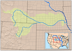
Map showing the Platte River watershed, including the North Platte and South Platte tributaries
|
|
|
Platte River with tributaries, lakes and cities
|
|
The Platte River /plæt/ is a major river in the state of Nebraska and is about 310 mi (500 km) long. Measured to its farthest source via its tributary the North Platte River, it flows for over 1,050 miles (1,690 km). The Platte River is a tributary of the Missouri River, which itself is a tributary of the Mississippi River which flows to the Gulf of Mexico. The Platte over most of its length is a muddy, broad, shallow, meandering stream with a swampy bottom and many islands—a braided stream. These characteristics made it too difficult for canoe travel, and it was never used as a major navigation route by European-American trappers or explorers.
The Platte is one of the most significant tributary systems in the watershed of the Missouri, draining a large portion of the central Great Plains in Nebraska and the eastern Rocky Mountains in Colorado and Wyoming. The river valley played an important role in the westward expansion of the United States, providing the route for several major emigrant trails, including the Oregon, California, Mormon and Bozeman trails. The first Europeans to see the Platte were French explorers and fur trappers about 1714; they first called it the Nebraskier (Nebraska), a transliteration of the name given by the Otoe people, meaning "flat water". This expression is very close to the French words "rivière plate" ("flat river"), the suspected origin of the name Platte River.
...
Wikipedia


