Park County, Colorado
| Park County, Colorado | |
|---|---|

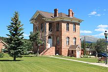
Old Park County Courthouse
|
|
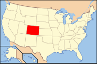
 Location in the U.S. state of Colorado |
|
 Colorado's location in the U.S. |
|
| Founded | November 1, 1861 |
| Seat | Fairplay |
| Largest town | Bailey |
| Area | |
| • Total | 2,211 sq mi (5,726 km2) |
| • Land | 2,194 sq mi (5,682 km2) |
| • Water | 17 sq mi (44 km2), 0.8% |
| Population (est.) | |
| • (2015) | 16,510 |
| • Density | 7.4/sq mi (3/km²) |
| Congressional districts | 2nd, 5th |
| Time zone | Mountain: UTC-7/-6 |
| Website | www |
Park County is one of the 64 counties in the U.S. state of Colorado. As of the 2010 census, the population was 16,206. The county seat is Fairplay. The county was named after the large geographic region known as South Park, which was named by early fur traders and trappers in the area.
Park County is included in the Denver-Aurora-Lakewood, CO Metropolitan Statistical Area. A majority of the county lies within the boundaries of the South Park National Heritage Area.
The geographic center of the State of Colorado is located in Park County.
Park County has been and is the location of several important mines, including the defunct Orphan Boy, which was discovered near Alma in 1861 and produced gold, silver, lead, and zinc. The historic Sweet Home Mine, also near Alma, is a former silver mine now known for its rhodochrosite mineral specimens.
According to the U.S. Census Bureau, the county has a total area of 2,211 square miles (5,730 km2), of which 2,194 square miles (5,680 km2) is land and 17 square miles (44 km2) (0.8%) is water.
The headwaters of the South Platte River are in Park County.
...
Wikipedia
