Gallatin River
| Gallatin River | |
| River | |
|
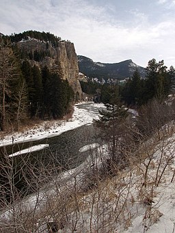
The Gallatin River during winter
|
|
| Country | United States |
|---|---|
| States | Wyoming, Montana |
| Source | Gallatin Range |
| - coordinates | 44°51′29″N 110°53′01″W / 44.85806°N 110.88361°W |
| Mouth | Missouri River |
| - coordinates | 45°56′20″N 111°29′33″W / 45.93889°N 111.49250°WCoordinates: 45°56′20″N 111°29′33″W / 45.93889°N 111.49250°W |
| Length | 120 mi (193 km) |
|
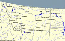
Montana rivers. The Gallatin is in the southwest corner.
|
|
The Gallatin River is a tributary of the Missouri River, approximately 120 mi (193 km long), in the U.S. states of Wyoming and Montana. It is one of three rivers, along with the Jefferson and Madison, that converge near Three Forks, Montana, to form the Missouri.
It rises in the northwest corner of Yellowstone National Park, in northwestern Wyoming, in the Gallatin Range of the Rocky Mountains. It flows northwest through Gallatin National Forest, past Big Sky, Montana, and joins the Jefferson and Madison approximately 30 mi (48 km) northwest of Bozeman. U.S. Highway 191 follows the river from the Wyoming border to just outside Bozeman.
The river was named in July 1805 by Meriwether Lewis at Three Forks. The eastern fork of the three, it was named for Albert Gallatin, the U.S. Treasury Secretary from 1801–14. The western fork was named for President Thomas Jefferson and the central fork for Secretary of State James Madison.
The Gallatin River is one of the best whitewater runs in the Yellowstone-Teton Area. In June, when the snowmelt is released from the mountains, the river has a class IV section called the "Mad Mile". This section is over a mile long and contains continuous stretches of challenging whitewater. Rafting companies offer trips on this river – on the Mad Mile Section as well as other, less challenging sections.
...
Wikipedia


