Meadowvale, Ontario
| Meadowvale | |
|---|---|
| Neighbourhood | |

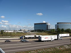
Mississauga Road overpass at Highway 401, in the industrial area of Meadowvale.
|
|
| Coordinates: 43°37′43″N 79°43′42″W / 43.62861°N 79.72833°W | |
| Country | Canada |
| Province | Ontario |
| Regional municipality | Peel |
| City | Mississauga |
| Time zone | EST (UTC-5) |
| • Summer (DST) | EDT (UTC-4) |
| Forward sortation area | L5N |
| Area code(s) | 905 and 289 |
| NTS Map | 030M12 |
| GNBC Code | FDHXD |
Meadowvale is a neighbourhood located in the northwestern part of Mississauga, just west of Toronto, Ontario, Canada. In the 19th and early 20th centuries, it was a village in Toronto Township. In the 1970s, Meadowvale was selected to be the name of a new town community for the newly (1974) incorporated City of Mississauga; the name was applied to a development a few miles west along Derry Road.
Meadowvale is located at 43°45′0″N 79°48′0″W / 43.75000°N 79.80000°W. The community is situated near the Credit River which lies to the east. Pine forests including other types of trees are along the Credit Valley which covers most of the central part of the subdivision. Another creek named Levi Creek runs to the south and southwest and is a tributary of the Credit lying to the south.
The rough boundaries of Meadowvale are: Ninth Line, Mavis Road, Highway 401, Britannia Road.
Meadowvale has two lakes, Aquitaine and Wabukayne, both of which were largely man-made. A system of parks and trails connects the two lakes, which are located about 1.5 kilometres apart.
The village of Meadowvale was established in the 1820s by Irish immigrants from New York state. In the village's early years, the main industry was milling, with the mills drawing power from the Credit River.Gooderham and Worts owned and operated many businesses in the village in the 1860s and 1870s, including a mill.
...
Wikipedia
