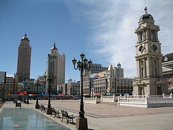
Manzhouli
|
Manzhouli 满洲里市 • ᠮᠠᠨᠵᠤᠤᠷᠬᠣᠲᠠ |
|
|---|---|
| Sub-prefecture-level city | |

Manzhouli Center
|
|
| Location in Inner Mongolia | |
| Coordinates: 49°36′N 117°26′E / 49.600°N 117.433°ECoordinates: 49°36′N 117°26′E / 49.600°N 117.433°E | |
| Country | China |
| Region | Inner Mongolia |
| Prefecture-level city | Hulunbuir |
| Area | |
| • Total | 696.3 km2 (268.8 sq mi) |
| Population | |
| • Total | 300,000 |
| • Density | 430/km2 (1,100/sq mi) |
| Time zone | China Standard (UTC+8) |
| Postal code | 021400 |
| Area code(s) | 0470 |
| Website | http://www.manzhouli.gov.cn/ |
| Manzhouli | |||||||||
| Traditional Chinese | 滿洲里 | ||||||||
|---|---|---|---|---|---|---|---|---|---|
| Simplified Chinese | 满洲里 | ||||||||
| Postal | Manchowli | ||||||||
|
|||||||||
| Transcriptions | |
|---|---|
| Standard Mandarin | |
| Hanyu Pinyin | Mǎnzhōulǐ |
| Wade–Giles | Man3-chou1-li3 |
Manzhouli (Chinese: 满洲里; pinyin: Mǎnzhōulǐ; Russian: Манжули; Mongolian: Манжуул хот; ᠮᠠᠨᠵᠤᠤᠷ ᠬᠣᠲᠠ) is a sub-prefecture-level city located in Hulunbuir prefecture-level city, Inner Mongolia Autonomous Region of the China (PRC). Located on the border with Russia, it is major land port of entry. It has an area of 696.3 square kilometres (268.8 sq mi) and a population of more than 300,000 (in 2010).
In ancient times the area was inhabited by many tribes that lived in Manchuria including the Donghu, the Xiongnu, the Xianbei, the Khitan, and the Mongols. During the decline of China's last dynasty, the Russian Empire forced the house of Qing (1644–1912) to cede the Outer Manchurian territory in the 1858 Treaty of Aigun. That treaty effectively made the Argun River, which originates in this area, the border between the China and Russia.
...
Wikipedia

