Mangystau
|
Mangystau Region Маңғыстау облысы Мангистауская область ماڭعىستاۋ وبلىسى |
||
|---|---|---|
| Region | ||

|
||
|
||
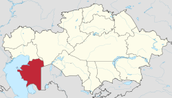
 Map of Kazakhstan, location of Mangystau Province highlighted |
||
| Coordinates: 43°52′N 052°00′E / 43.867°N 52.000°ECoordinates: 43°52′N 052°00′E / 43.867°N 52.000°E | ||
| Country |
|
|
| Capital | Aktau | |
| Government | ||
| • Akim | Alik Aidarbayev | |
| Area | ||
| • Total | 165,642 km2 (63,955 sq mi) | |
| Highest elevation | 556 m (1,824 ft) | |
| Lowest elevation | -132 m (−433 ft) | |
| Population (2013-02-01) | ||
| • Total | 596,706 | |
| • Density | 3.6/km2 (9.3/sq mi) | |
| Time zone | West (UTC+5) | |
| • Summer (DST) | not observed (UTC+5) | |
| Postal codes | 130000 | |
| Area codes | +7 (729) | |
| ISO 3166 code | KZ-MAN | |
| Vehicle registration | 12, R | |
| Districts | 5 | |
| Cities | 3 | |
| Townships | 6 | |
| Villages | 30 | |
| Website | mangystau |
|
Mangystau Region (Kazakh: Маңғыстау облысы, Mañğıstaw oblısı, ماڭعىستاۋ وبلىسى) is a region of Kazakhstan. Its capital is Aktau (a seaport), which has a population of 154,500 (2004 census); the entire Mangystau Region has a population of 373,400.
The region is located in the southwest of the country, and includes Mangyshlak Peninsula. It has much of Kazakhstan's Caspian Shore. It also borders neighboring countries Turkmenistan and Uzbekistan. Mangystau also borders two other Kazakh regions (counter-clockwise), Aktobe Region and Atyrau Region. The area of the region is 165,600 square kilometers. Engineers discovered petroleum in the area in the days of the Soviet Union, drilling commenced, and much of the area was built up around the industry.
The territory of Mangystau includes lots of different landscapes and desert lands: Caspian lowland, plateaus (Usturt, Mangyshlak, Kendirli-Kayasan), mountains (Aktau, Karatau), cavities, desert, mountains and mountain ridges. That kind of landscape forms an original multigraded labyrinth, painted with green, yellow, pink and red sediment of loam. The highest point is Otpan mountain at 556 metres (1,824 ft). The lowest point is the bottom of Karagie cavity, 132 metres (433 ft) below sea level.
Due to its vast territory, the region has a wide variety of climate conditions. The climate of north Mangystau is cold in winter due to its settlement in Ustyurt Plateau, the location of the plateau is mainly above sea level. On the whole, the climate is continental with cold winters and mild summers. The average temperature −3 °C (27 °F) in January and +26 °C (79 °F) in July. The average annual rainfall is 150 millimetres (5.9 in).
The first written sources on Mangystau Region date back to the 9th century AD. According to Arabic geographers, it was uninhabited until the tenth century when groups opposing the Turkmen Oghuz settled and found sources of water and grassland. The mountain called Binkishlah (unidentified) would have marked the border between Khwarezm and the Khanate of the Khazars. These Turkmen were vassals of the Khazars, at the beginning of the thirteenth century when Yaqut al-Hamawi and Ibn al-Athir mention the name of Mankashlagh. Ibn al-Athir tells of a Turkish principality with a medina with the same name as the territory that existed from the late eleventh century. In 1097 a struggle between Kutb al-Din Muhammad, Khwarezm governor of Seljuks and Tugrul Tehghin occurred. In 1127, Atsiz occupied the whole peninsula. During Khwarezmshah rule, it was part of firstly Gorgan province, later Mazandaran Province.
...
Wikipedia

