Linkou, Taipei
|
Linkou 林口區 |
|
|---|---|
| District | |
| Linkou District | |
 |
|
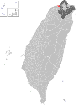
 Location of Linkou in Xinbei City |
|
| Coordinates: 25°06′06″N 121°21′47″E / 25.10167°N 121.36306°ECoordinates: 25°06′06″N 121°21′47″E / 25.10167°N 121.36306°E | |
| Country | Taiwan |
| Region | Northern Taiwan |
| Special municipality | New Taipei City (新北市) |
| Area | |
| • Total | 54.15 km2 (20.91 sq mi) |
| Population (January 2016) | |
| • Total | 100,554 |
| Time zone | CST (UTC+8) |
| Postal code | 244 |
| Website | http://www.linkou.ntpc.gov.tw |
| Linkou District | |||||||||||||||||||
| Chinese | 林口區 | ||||||||||||||||||
|---|---|---|---|---|---|---|---|---|---|---|---|---|---|---|---|---|---|---|---|
|
|||||||||||||||||||
| Transcriptions | |
|---|---|
| Standard Mandarin | |
| Hanyu Pinyin | Línkǒu Qū |
| Bopomofo | ㄌㄧㄣˊ ㄎㄡˇ ㄑㄩ |
| Tongyong Pinyin | Línkǒu Cyu |
| Hakka | |
| Romanization | Nà-khiéu Khî |
| Southern Min | |
| Hokkien POJ | Nâ-kháu khu |
Linkou District (Chinese: 林口區; pinyin: Línkǒu Qū; Pe̍h-ōe-jī: Nâ-kháu khu) is a district in the western part of New Taipei in northern Taiwan.
It has a population of 98,524 as of April 2015 and has the fastest growth rate among all districts in New Taipei City.
Tunglin Village, Linkou Village, Xilin Village, Jinghu Village, Zhonghu Village, Hubei Village, Hunan Village, Nanshi Village, Renai Village, Lilin Village, Tungshi Village, Liyuan Village, Dingfu Village, Xiafu Village, Jiabao Village, Ruiping Village, Taiping Village.
Linkou is served by the National Highway No. 1, as well as Provincial Highways No. 15 and No. 61. County routes 105, 106 and 108 also run through the district.
...
Wikipedia
