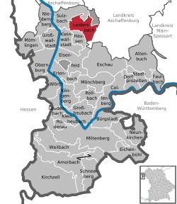
Leidersbach
| Leidersbach | ||
|---|---|---|
|
||
| Coordinates: 49°54′N 9°13′E / 49.900°N 9.217°ECoordinates: 49°54′N 9°13′E / 49.900°N 9.217°E | ||
| Country | Germany | |
| State | Bavaria | |
| Admin. region | Unterfranken | |
| District | Miltenberg | |
| Government | ||
| • Mayor | Friedrich Wörl (CSU) | |
| Area | ||
| • Total | 19.81 km2 (7.65 sq mi) | |
| Elevation | 196 m (643 ft) | |
| Population (2015-12-31) | ||
| • Total | 4,788 | |
| • Density | 240/km2 (630/sq mi) | |
| Time zone | CET/CEST (UTC+1/+2) | |
| Postal codes | 63849 | |
| Dialling codes | 06028, 06092 | |
| Vehicle registration | MIL | |
| Website | www.leidersbach.de | |
Leidersbach is a community in the Miltenberg district in the Regierungsbezirk of Lower Franconia (Unterfranken) in Bavaria, Germany.
Leidersbach lies roughly 10 km south of Aschaffenburg in the Spessart.
From the north, clockwise: Forst Hohe Wart (gemeindefreies Gebiet), Mespelbrunn, Heimbuchenthal, Hausen, Kleinwallstadt, Sulzbach am Main.
Leidersbach's Ortsteile are Leidersbach, Ebersbach, Roßbach and Volkersbrunn.
The Schlossberg, a hill between Ebersbach and Soden, part of neighbouring Sulzbach, was already inhabited in Neolithic times and in the period of the Hallstatt culture (see Attractions).
The founding of the community itself came about in the Middle Ages. By comparing the place with other places with similar name origins, it can be inferred that the places ending in —bach (meaning “brook” in German) were likely founded in Carolingian times in the late 8th century. Ebersbach had its first documentary mention in 1183, and Leidersbach and Roßbach had theirs in 1200. Volkersbrunn’s first written reference is from 1248.
Already by this time, these villages belonged to Electoral Mainz. When this state was dissolved by the 1803 Reichsdeputationshauptschluss, the villages passed to the newly formed Principality of Aschaffenburg, with which they passed in 1814 (by this time it had become a part of the Grand Duchy of Frankfurt) to the Kingdom of Bavaria.
...
Wikipedia


