Spessart
| Spessart | |
|---|---|

Rohrberg nature reserve, site of some of the most ancient oaks and beeches in the Spessart
|
|
| Highest point | |
| Peak | Geiersberg |
| Elevation | 586 m (1,923 ft) NN |
| Coordinates | 49°54′9″N 9°25′43″E / 49.90250°N 9.42861°ECoordinates: 49°54′9″N 9°25′43″E / 49.90250°N 9.42861°E |
| Dimensions | |
| Area | 2,440 km2 (940 sq mi) |
| Geography | |
| Country | Germany |
| State/Province | Hesse, Bavaria |
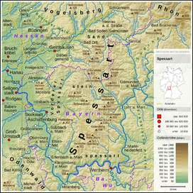
Spessart is a Mittelgebirge, a range of low wooded mountains, in the States of Bavaria and Hesse in Germany. It is bordered by the Vogelsberg, Rhön and Odenwald. The highest elevation is the Geiersberg at 586 metres NN.
The name is derived from "Spechtshardt". Specht is the German word for woodpecker and Hardt is an outdated word meaning "hilly forest".
Spessart is a Mittelgebirge, located in the Lower Franconia region of Bavaria and in Hesse, Germany. It is bordered by other ranges of hills: the Vogelsberg in the north, Rhön in the northeast and Odenwald in the southwest. Another way of describing the extent of the range is by naming the rivers that border it: the Main in the south and west, the Kinzig in the north and the Sinn in the northeast. The area of the Spessart totals around 2,440 square kilometres, of which 1,710 square kilometres are part of Bavaria.
The highest elevation is the Geiersberg at 586 metres NN. The highest elevation in the Hessian part of the Spessart is Hermannskoppe at 567 metres.
Since the admission of Croatia to the European Union (EU), the geographical centre of the EU is located in the village of Westerngrund, near Schöllkrippen, according to the Institut de Géographie in Paris. Previously, the centre was located west of Gelnhausen.
...
Wikipedia

