Schöllkrippen
| Schöllkrippen | ||
|---|---|---|

Country road to Schöllkrippen, with the church St Katharina
|
||
|
||
| Coordinates: 50°05′07″N 09°14′45″E / 50.08528°N 9.24583°ECoordinates: 50°05′07″N 09°14′45″E / 50.08528°N 9.24583°E | ||
| Country | Germany | |
| State | Bavaria | |
| Admin. region | Unterfranken | |
| District | Aschaffenburg | |
| Municipal assoc. | Schöllkrippen | |
| Government | ||
| • Mayor | Rainer Pistner | |
| Area | ||
| • Total | 12.64 km2 (4.88 sq mi) | |
| Elevation | 206 m (676 ft) | |
| Population (2015-12-31) | ||
| • Total | 4,206 | |
| • Density | 330/km2 (860/sq mi) | |
| Time zone | CET/CEST (UTC+1/+2) | |
| Postal codes | 63825 | |
| Dialling codes | 06024 | |
| Vehicle registration | AB | |
| Website | www.schoellkrippen.de | |
Schöllkrippen is a market community in the Aschaffenburg district in the Regierungsbezirk of Lower Franconia (Unterfranken) in Bavaria, Germany and seat of the Verwaltungsgemeinschaft (municipal association) of Schöllkrippen. It has a total population of around 4,000.
Schöllkrippen is the largest settlement of the Kahlgrund and lies on the river Kahl on the western edge of the Spessart (range). The main Ortsteil of Schöllkrippen lies at the foot of the Reuschberg.
Schöllkrippen's Ortsteile are Schöllkrippen, Schneppenbach and Hofstädten.
Schöllkrippen Ortsteil consists of the following Orte: Ernstkirchen, Langenborn, Reuschberg, Röderhof, Schabernack and Schöllkrippen proper.
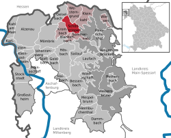
The neighbouring communities are from the north (clockwise): Westerngrund, Kleinkahl, Schöllkrippener Forst (an unincorporated area), Sommerkahl, Blankenbach, Krombach and Geiselbach.
...
Wikipedia


