Lantau

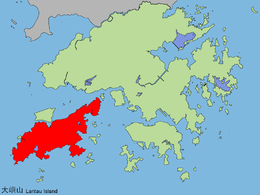
Lantau Island is highlighted in red.
|
|
| Geography | |
|---|---|
| Location | Southwest Hong Kong |
| Area | 147.16 km2 (56.82 sq mi) |
| Highest elevation | 934 m (3,064 ft) |
| Highest point | Lantau Peak |
| Administration | |
| Islands District and Tsuen Wan District | |
| Demographics | |
| Population | 105,000 (2011) |
| Lantau Island | |||||||||||||||||

Overall view of Lantau Island, seen from the south-west.
|
|||||||||||||||||
| Traditional Chinese | 大嶼山 | ||||||||||||||||
|---|---|---|---|---|---|---|---|---|---|---|---|---|---|---|---|---|---|
| Simplified Chinese | 大屿山 | ||||||||||||||||
| Literal meaning | "big island mountain" | ||||||||||||||||
|
|||||||||||||||||
| Transcriptions | |
|---|---|
| Standard Mandarin | |
| Hanyu Pinyin | Dà yǔ shān / Dà yǔ shān |
| Hakka | |
| Romanization | Tai4 yi2 san1 |
| Yue: Cantonese | |
| Yale Romanization | Daaih yùh sāan |
| Jyutping | Daai6 jyu4 saan1 |
Lantau Island (also Lantao Island; Chinese: 大嶼山) is the largest island in Hong Kong, located at the mouth of the Pearl River. Administratively, most of Lantau Island is part of the Islands District of Hong Kong. A small northeastern portion of the island is located in the Tsuen Wan District.
Originally the site of fishing villages, the island has been developed in recent years with the construction of Tung Chung New Town on its north-western coast and the completion of several major infrastructure projects, including Lantau Link (1997), Hong Kong International Airport (1998), Hong Kong Disneyland (2005) and Ngong Ping 360 (2006).
With a land mass of 147.16 square kilometres (56.82 sq mi), it is the largest island in Hong Kong, almost twice the size of Hong Kong Island. Lantau Island primarily consists of mountainous terrain. Lantau Peak (934 metres (3,064 ft)) is the highest point of the island. It is the second highest in Hong Kong, after Tai Mo Shan, and is almost twice the height of Victoria Peak. Other mountains include Sunset Peak at 898 m (2,946 ft), Lin Fa Shan at 766 m (2,513 ft), Nei Lak Shan at 751 m (2,464 ft) and Yi Tung Shan at 747 m (2,451 ft).
...
Wikipedia
