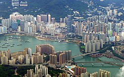
Tsuen Wan District
|
Tsuen Wan 荃灣區 |
||
|---|---|---|
| District | ||
| Tsuen Wan District | ||

Day view of the Tsuen Wan District
|
||
|
||
 Location of Tsuen Wan District within Hong Kong |
||
| Coordinates: 22°21′46″N 114°07′45″E / 22.36281°N 114.12907°ECoordinates: 22°21′46″N 114°07′45″E / 22.36281°N 114.12907°E | ||
| Country |
|
|
| Region | New Territories | |
| Constituencies | 17 | |
| Government | ||
| • District Council Chairman | 鍾偉平 Chung Wai-ping, SBS, MH | |
| Area | ||
| • Total | 60.70 km2 (23.44 sq mi) | |
| Population (2011) | ||
| • Total | 304,637 | |
| • Density | 5,000/km2 (13,000/sq mi) | |
| Time zone | Hong Kong Time (UTC+8) | |
| Website | Tsuen Wan District Council | |
| Tsuen Wan District | |||||||||||||||||||
| Traditional Chinese | 荃灣區 | ||||||||||||||||||
|---|---|---|---|---|---|---|---|---|---|---|---|---|---|---|---|---|---|---|---|
| Simplified Chinese | 荃湾区 | ||||||||||||||||||
| Cantonese Yale | Chyùhn Wāan Kēui | ||||||||||||||||||
|
|||||||||||||||||||
| Transcriptions | |
|---|---|
| Standard Mandarin | |
| Hanyu Pinyin | Quánwānqū |
| Hakka | |
| Romanization | Cien2 van1 |
| Yue: Cantonese | |
| Yale Romanization | Chyùhn Wāan Kēui |
| IPA | [tsʰy̏ːn.wáːn kʰɵ́y̯] |
| Jyutping | Cyun4 waan1 keoi1 |
Tsuen Wan District (Chinese: 荃灣區; Cantonese Yale: Chyùhn Wāan Kēui) is one of the 18 districts of Hong Kong. It is located in the New Territories and is served by the Tsuen Wan Line of the MTR metro system. Its area is 60,7 km². Its residents, who mostly live in Tsuen Wan Town, enjoy the highest income in the New Territories.
Part of the Tsuen Wan New Town is located in the Tsuen Wan District. An exclave of Tsuen Wan is also located on the northeastern part of Lantau island.
The district was set up in 1982 covering the present-day Tsuen Wan District and Kwai Tsing District. Kwai Chung and the island of Tsing Yi were split from Tsuen Wan District in the mid-1980s, and subsequently formed a new district known as Kwai Tsing.
The Sam Tung Uk Museum is a cultural and agricultural museum and was set up in a former Hakka walled village. Behind Tsuen Wan is Shin Mun reservoir, a valley that was once home to 10 villages that grew mostly pineapples. The dam that stops the reservoir is called Po Lo Pa, lit. pineapple dam. There were once disputes and fights among the Shing Mun valley dwellers and Tsuen Wan residents during the 18th century, over the levying of taxes for pineapple sales. The reservoir valley also has a disused lead mine, where some of the residents of Tsuen Wan used to work. Behind this is Tai Mo Shan, the tallest hill in Hong Kong.
...
Wikipedia

