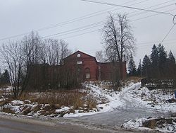
Lakhdenpokhya
| Lakhdenpokhya (English) Лахдепохья (Russian) Lahdenpohja (Finnish) |
|
|---|---|
| - Town - | |
 An abandoned Lutheran church in Lakhdenpokhya |
|
 Location of the Republic of Karelia in Russia |
|
|
|
|
|
|
|
|
|
|
| Administrative status (as of April 2013) | |
| Country | Russia |
| Federal subject | Republic of Karelia |
| Administrative district | Lakhdenpokhsky District |
| Administrative center of | Lakhdenpokhsky District |
| Municipal status (as of April 2013) | |
| Municipal district | Lakhdenpokhsky Municipal District |
| Urban settlement | Lakhdenpokhskoye Urban Settlement |
| Administrative center of | Lakhdenpokhsky Municipal District, Lakhdenpokhskoye Urban Settlement |
| Head | Lyudmila Glytenko |
| Statistics | |
| Population (2010 Census) | 7,813 inhabitants |
| Time zone | MSK (UTC+03:00) |
| Town status since | 1945 |
|
|
|
| on | |
Lakhdenpokhya (Russian: Лахденпо́хья; Finnish: Lahdenpohja) is a town and the administrative center of Lakhdenpokhsky District of the Republic of Karelia, Russia, located 330 kilometers (210 mi) west of Petrozavodsk on the Aurayoki River. Population: 7,813 (2010 Census);8,751 (2002 Census);10,429 (1989 Census).
![]() Russia 1600–1617
Russia 1600–1617![]() Sweden 1617–1721
Sweden 1617–1721![]() Russia (empire) 1721–1812
Russia (empire) 1721–1812
![]() Finland 1812-1917,
Finland 1812-1917,
autonomous part of
- ![]() Russia (empire)
Russia (empire)
- ![]() Russia (republic)
Russia (republic)
- ![]() Russia (Soviet republic)
Russia (Soviet republic)![]() >
>![]() Finland 1917–1940
Finland 1917–1940![]() >
>![]() >
>![]() Soviet Union 1940–1991
Soviet Union 1940–1991
- conquered by Finland
in the Continuation War (1941–1944)![]() >
>![]() Russia from 1991
Russia from 1991
...
Wikipedia


