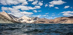
Lake Pangong
| Pangong Tso | |
|---|---|
 |
|
| Location | Ladakh, Jammu and Kashmir, India; Rutog County, Tibet, China |
| Coordinates | 33°43′04.59″N 78°53′48.48″E / 33.7179417°N 78.8968000°ECoordinates: 33°43′04.59″N 78°53′48.48″E / 33.7179417°N 78.8968000°E |
| Type |
Soda lake dimictic lake (east basin) cold monomictic lake (west basin) |
| Basin countries | China, India |
| Max. length | 134 km (83 mi) |
| Max. width | 5 km (3.1 mi) |
| Surface area | approx. 700 km2 (270 sq mi) |
| Max. depth | 328 ft. (100 m) |
| Surface elevation | 4,250 metres (13,940 ft) |
| Frozen | during winter |
| Pangong Tso | |||||||
| Traditional Chinese | 班公錯 | ||||||
|---|---|---|---|---|---|---|---|
| Simplified Chinese | 班公错 | ||||||
|
|||||||
|
|||||||
Pangong Tso (Tibetan: སྤང་གོང་མཚོ, Wylie: spang gong mtsho; Hindi: पांगोंग त्सो; Chinese: 班公错; pinyin: Bāngōng Cuò), Tibetan for "high grassland lake", also referred to as Pangong Lake, is an endorheic lake in the Himalayas situated at a height of about 4,350 m (14,270 ft). It is 134 km (83 mi) long and extends from India to China. Approximately 60% of the length of the lake lies in China. The lake is 5 km (3.1 mi) wide at its broadest point. All together it covers 604 km2. During winter the lake freezes completely, despite being saline water. It is not a part of Indus river basin area and geographically a separate land locked river basin.
The lake is in the process of being identified under the Ramsar Convention as a wetland of international importance. This will be the first trans-boundary wetland in South Asia under the convention.
The brackish water of the lake has very low micro-vegetation. Guides report that there are no fish or other aquatic life in the lake, except for some small crustaceans. On the other hand, visitors see numerous ducks and gulls over and on the lake surface. There are some species of scrub and perennial herbs that grow in the marshes around the lake.
...
Wikipedia

