Lake Owens
| Owens Lake | |
|---|---|

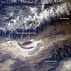
Image of the Owens Valley from the International Space Station -- oriented top = true west.
|
|
| Location |
Sierra Nevada Inyo County, California, United States |
| Coordinates | 36°26′00″N 117°57′03″W / 36.433269°N 117.950916°WCoordinates: 36°26′00″N 117°57′03″W / 36.433269°N 117.950916°W |
| Type | Flat |
| Primary inflows |
Owens River Natural springs and wells |
| Basin countries | United States |
| Max. length | 17.5 mi (28.2 km) |
| Max. width | 10 mi (16 km) |
| Max. depth | 3 ft (0.91 m) |
| Surface elevation | 3,556 ft (1,084 m) |
| References | GNIS feature ID 272820 |
Owens Lake is a mostly dry lake in the Owens Valley on the eastern side of the Sierra Nevada in Inyo County, California. It is about 5 miles (8.0 km) south of Lone Pine, California. Unlike most dry lakes in the Basin and Range Province that have been dry for thousands of years, Owens held significant water until 1913, when much of the Owens River was diverted into the Los Angeles Aqueduct, causing Owens Lake to desiccate by 1926. Today, some of the flow of the river has been restored, and the lake now contains some water. Nevertheless, as of 2013, it is the largest single source of dust pollution in the United States.
Owens Lake was given that name by the explorer John C. Fremont, in honor of one of his guides, Richard Owens.
Before the diversion of the Owens River, Owens Lake was up to 12 miles (19 km) long and 8 miles (13 km) wide, covering an area of up to 108 square miles (280 km2). In the last few hundred years the lake had an average depth of 23 to 50 feet (7.0 to 15.2 m), and sometimes overflowed to the south after which the water would flow into the Mojave Desert. In 1905, the lake's water was thought to be “excessively saline.”
It is thought that in the late about 11-12,000 years ago Owens Lake was even larger, covering nearly 200 square miles (520 km2) and reaching a depth of 200 feet (61 m). The increased inflow from the Owens River, from melting glaciers of the post-Ice Age Sierra Nevada, caused Owens Lake to overflow south through Rose Valley into another now-dry lakebed, China Lake, in the Indian Wells Valley near Ridgecrest, California. After the glaciers melted, the lake waters receded, and this accelerated with human exploitation of the lake even before the Los Angeles Aqueduct was built, due to Owens Valley farmers who had already appropriated most of the Owens River's tributaries' flow, causing the lake level to drop slightly each year.
...
Wikipedia
