Owens River
| Owens River | |
| Wakopee | |
|
Owens River south of Poverty Hills
|
|
| Country | United States |
|---|---|
| State | California |
| Districts | Mono County, Inyo County |
| Tributaries | |
| - left | Spring Valley Wash, Silver Canyon Creek, Coldwater Canyon Creek |
| - right | Hot Creek, Rock Creek, Bishop Creek, Big Pine Creek, Birch Creek, Independence Creek, Lone Pine Creek |
| Cities | Mesa, Bishop, Big Pine, Elna (site), Chrysopolis (site), Independence, Lone Pine |
| Source | Confluence of Deadman Creek and an unnamed stream |
| - location | Inyo National Forest, Mono County |
| - elevation | 7,251 ft (2,210 m) |
| - coordinates | 37°45′01″N 118°56′20″W / 37.75028°N 118.93889°W |
| Mouth | Owens Lake |
| - location | A few miles northwest of Keeler, Inyo County |
| - elevation | 3,592 ft (1,095 m) |
| - coordinates | 36°32′31″N 117°58′45″W / 36.54194°N 117.97917°WCoordinates: 36°32′31″N 117°58′45″W / 36.54194°N 117.97917°W |
| Length | 183 mi (295 km), north-south |
| Basin | 2,604 sq mi (6,744 km2) |
| Discharge | for Big Pine, CA |
| - average | 389 cu ft/s (11 m3/s) |
| - max | 3,220 cu ft/s (91 m3/s) |
| - min | 51.9 cu ft/s (1 m3/s) |
|
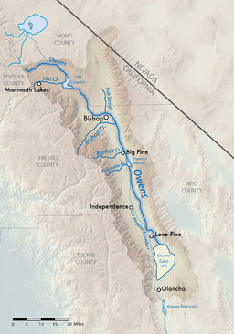
Map of the Owens Lake watershed, including Los Angeles Aqueduct system
|
|
The Owens River is a river in southeastern California in the United States, approximately 183 miles (295 km) long. It drains into and through the Owens Valley, an arid basin between the eastern slope of the Sierra Nevada and the western faces of the Inyo and White Mountains. The river terminates at the endorheic Owens Lake south of Lone Pine, at the bottom of a 2,600 sq mi (6,700 km2) watershed.
In the early 1900s the Owens was the focus of the California Water Wars, fought between the city of Los Angeles and the inhabitants of Owens Valley over the construction of the Los Angeles Aqueduct. Since 1913, the Owens River has been diverted to Los Angeles, causing the ruin of the valley's economy and the drying of Owens Lake. In winter 2006, the Los Angeles Department of Water and Power restored 5% of the pre-aqueduct flow to the river, by court order, allowing the Owens River Gorge, the river bed in the valley, and Owens Lake to contain a small amount of water.
The river rises in the Sierra Nevada in southwestern Mono County, approximately 15 miles (24.1 km) south of Mono Lake and 35 miles (56.3 km) east of Yosemite Valley. It flows southeast across the Long Valley Caldera, through Lake Crowley reservoir, then descends through the 20-mile-long (32 km) Owens River Gorge, emerging at the north end of the Owens Valley northwest of Bishop. In the area around Bishop, it is diverted through many ditches to irrigate the surrounding farming region. It flows south-southeast through the Owens Valley between the Sierra Nevada on the west and the White and Inyo Mountains on the east, past Big Pine. Approximately 14 miles (22.5 km) south-southeast of Big Pine, most of the remaining river is diverted into the Los Angeles Aqueduct, completed in 1913 to supply municipal, recreational and agricultural water to Los Angeles. The remaining river flows through the southern valley, flanked by the Los Angeles Aqueduct, past Lone Pine, entering the lake bed of predominantly dry Owens Lake at the southern end of Owens Valley.
...
Wikipedia


