Laingsburg Local Municipality
| Laingsburg | ||
|---|---|---|
| Local municipality | ||
|
||
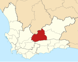
 Location of Laingsburg Local Municipality within the Western Cape |
||
| Coordinates: 33°15′S 21°00′E / 33.250°S 21.000°ECoordinates: 33°15′S 21°00′E / 33.250°S 21.000°E | ||
| Country | South Africa | |
| Province | Western Cape | |
| District | Central Karoo | |
| Seat | Laingsburg | |
| Wards | 4 | |
| Government | ||
| • Type | Municipal council | |
| • Mayor | Willem Theron (DA) | |
| Area | ||
| • Total | 8,784 km2 (3,392 sq mi) | |
| Population (2011) | ||
| • Total | 8,289 | |
| • Density | 0.94/km2 (2.4/sq mi) | |
| Racial makeup (2011) | ||
| • Black African | 7.0% | |
| • Coloured | 79.0% | |
| • Indian/Asian | 0.2% | |
| • White | 13.3% | |
| First languages (2011) | ||
| • Afrikaans | 94.3% | |
| • English | 1.7% | |
| • Xhosa | 1.2% | |
| • Other | 2.8% | |
| Time zone | SAST (UTC+2) | |
| Municipal code | WC051 | |
Laingsburg Municipality is a municipality located in the Western Cape Province of South Africa. As of 2011[update] the population is 8,289. Its municipality code is WC051.
The municipality covers an area of 8,784 square kilometres (3,392 sq mi) on the south-western edge of the Great Karoo. The southern edge of the municipality lies along the Anysberg and Swartberg mountains, while its northern edge is the provincial border with the Northern Cape. It abuts on the Beaufort West and Prince Albert Municipalities to the east, the Kannaland Municipality to the south, the Langeberg, Breede Valley and Witzenberg Municipalities to the west, and the Karoo Hoogland Municipality to the north.
According to the 2011 census the municipality has a population of 8,289 people in 2,408 households. Of this population, 79.0% describe themselves as "Coloured", 13.3% as "White", and 7.0% as "Black African". The first language of 94.3% of the population is Afrikaans, while 1.7% speak English and 1.2% speak Xhosa.
...
Wikipedia

