La Salle County, Texas
| La Salle County, Texas | |
|---|---|

The La Salle County Courthouse in Cotulla has undergone extensive renovation and nears completion in the summer of 2013.
|
|
 Location in the U.S. state of Texas |
|
 Texas's location in the U.S. |
|
| Founded | 1880 |
| Named for | René-Robert Cavelier, Sieur de La Salle |
| Seat | Cotulla |
| Largest city | Cotulla |
| Area | |
| • Total | 1,494 sq mi (3,869 km2) |
| • Land | 1,487 sq mi (3,851 km2) |
| • Water | 7.5 sq mi (19 km2), 0.5% |
| Population | |
| • (2010) | 6,886 |
| • Density | 4.6/sq mi (2/km²) |
| Congressional districts | 23rd, 28th |
| Time zone | Central: UTC-6/-5 |
| Website | lasallecountytx |
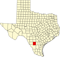
La Salle County is a county located in the U.S. state of Texas. As of the 2010 census, its population was 6,886. Its county seat is Cotulla. The county was created in 1858 and later organized in 1880. It is named for René-Robert Cavelier, Sieur de La Salle, a 17th-century French explorer.
The area of present-day La Salle County was occupied by the Coahuiltecan Indians until the 18th century, when they were squeezed out by the Spanish from the south and the Apache from the north. After the Mexican War of Independence, the Mexican government used land grants to encourage settlement, but very few settled in the area. By 1836, the area was entirely populated by Indians.
Between the Texas Revolution and the Mexican War the area of present-day La Salle County lay in the disputed area between the Rio Grande and the Nueces River. Desperadoes ruled the area, as neither the Mexican government nor the Republic of Texas could gain control. The Treaty of Guadalupe Hidalgo assigned the Nueces Strip to Texas in 1848, but outlaws and hostile Indians delayed settlement of the area.
La Salle County was officially formed in 1858 from the Bexar District. The first settlements were established on the road from Laredo to San Antonio. In 1852, the Army established Fort Ewell near present-day Artesia Wells where the road crossed the Nueces River to protect travelers on the road. The fort was abandoned in 1854, and the remaining inhabitants moved to the settlement of Guajoco, located one and a half miles from the fort. By 1871, around 60 people lived in Guajoco, mostly of Mexican descent.
...
Wikipedia
