Kuching, Sarawak
| Kuching | |||
|---|---|---|---|
| City and State Capital | |||
| City of Kuching Bandar Raya Kuching |
|||
| Other transcription(s) | |||
| • Jawi | کوچيڠ | ||
| • Chinese | 古晉 | ||

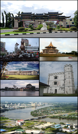
Clockwise from top right: Chinatown, State Assembly building, Fort Margherita, Pending Bridge, The Astana, Sarawak State Museum and cat statues.
|
|||
|
|||
| Nickname(s): "Cat City", Bandaraya Perpaduan (City of Unity) |
|||
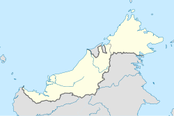
| Location in East Malaysia | |||
| Coordinates: 1°33′36″N 110°20′42″E / 1.56000°N 110.34500°ECoordinates: 1°33′36″N 110°20′42″E / 1.56000°N 110.34500°E | |||
| Country |
|
||
| State |
|
||
| Division | Kuching Division | ||
| District | Kuching District | ||
| Founded by the Sultanate of Brunei | 1827 | ||
| Settled by James Brooke | 18 August 1842 | ||
| Municipality | 1 January 1953 | ||
| Granted city status | 1 August 1988 | ||
| Government | |||
| • Type | Kuching South : Mayor–council government Kuching North : Council–manager government | ||
| • Mayor (Kuching South) | Dato' James Chan Khay Syn | ||
| • Commissioner (Kuching North) | Datuk Abang Wahap Abang Julai | ||
| Area | |||
| • City of Kuching | 431.02 km2 (166.42 sq mi) | ||
| • Metro | 2,030.94 km2 (784.15 sq mi) | ||
| • Kuching North | 369.48 km2 (142.66 sq mi) | ||
| • Kuching South | 61.54 km2 (23.76 sq mi) | ||
| Sourced from the DBKU official website | |||
| Elevation | 8 m (26 ft) | ||
| Highest elevation | 810.2 m (2,658.1 ft) | ||
| Lowest elevation | 0 m (0 ft) | ||
| Population (2010) | |||
| • City of Kuching | 325,132 | ||
| • Density | 754.33/km2 (1,953.7/sq mi) | ||
| • Metro | 684,112 | ||
| • Metro density | 336.8/km2 (872/sq mi) | ||
| • Demonym | Kuchingite / Orang Kuching | ||
| Sourced from Population and Housing Census of Malaysia 2010. Kuching metropolitan area (Greater Kuching) includes population of 358,980 in the Padawan municipality and Samarahan district. | |||
| Time zone | MST (UTC+8) | ||
| • Summer (DST) | Not observed (UTC+8) | ||
| Postal code | 93xxx | ||
| Area code(s) | 082 (landline only) | ||
| Vehicle registration | QA and QK (for all vehicles except taxis) HQ (for taxis only) |
||
| Website | Kuching North: www Kuching South: www |
||
Kuching /ˈkuːtʃɪŋ/ (Jawi: کوچيڠ, Chinese: 古晉; pinyin: Gǔjìn), officially the City of Kuching, is the capital and the most populous city in the state of Sarawak in Malaysia. It is also the capital of Kuching Division. The city is situated on the Sarawak River at the southwest tip of the state of Sarawak on the island of Borneo and covers an area of 431 square kilometres (166 sq mi) with a population about 165,642 in the Kuching North administrative region and 159,490 in the Kuching South administrative region—a total of 325,132 people.
Kuching was the third capital of Sarawak in 1827 during the administration of the Bruneian Empire. In 1841, Kuching became the capital of Sarawak after Sarawak was ceded to James Brooke for helping the Bruneian empire in crushing a rebellion particularly the interior borneo dweller Dayak people who later became his loyal followers. The town continued to receive attention and development during the rule of Charles Brooke such as the construction of a sanitation system, hospital, prison, fort, and a bazaar. In 1941, the Brooke administration had a Centenary Celebration in Kuching. During World War II, Kuching was occupied by Japanese forces from 1942 to 1945. The Japanese government set up a Batu Lintang camp near Kuching to hold prisoners of war and civilian internees. After the war, the town survived intact. However, the last Rajah of Sarawak, Sir Charles Vyner Brooke decided to cede Sarawak as part of British Crown Colony in 1946. Kuching remained as capital during the Crown Colony period. After the formation of Malaysia in 1963, Kuching retained its status as state capital and was granted city status in 1988. Since then, the Kuching city is divided into two administrative regions managed by two separate local authorities. The administrative centre of Sarawak state government is located at Wisma Bapa Malaysia, Kuching.
...
Wikipedia


