Krementschuk
|
Kremenchuk Кременчук |
|||
|---|---|---|---|
| City | |||

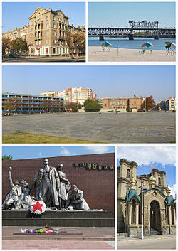
Top left:Lenina Street, Top right:Dniepur River and Kryukov Bridge, Center:Victory Square, Bottom left:Memorial of Vichno Zhyuyn, Bottom right:Saint Nicolas Church
|
|||
|
|||
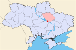
 Map of Ukraine with Kremenchuk highlighted within Poltava Oblast. |
|||
| Coordinates: 49°04′00″N 33°25′00″E / 49.06667°N 33.41667°ECoordinates: 49°04′00″N 33°25′00″E / 49.06667°N 33.41667°E | |||
| Country |
|
||
| Oblast | Poltava Oblast | ||
| Raion | Kremenchutskyi Raion | ||
| Founded | 1571 | ||
| Government | |||
| • Mayor | Vitalij Maleckiy | ||
| Area | |||
| • Total | 96 km2 (37 sq mi) | ||
| Elevation | 80 m (260 ft) | ||
| Population (2015) | |||
| • Total | 225,216 | ||
| • Density | 2,448/km2 (6,340/sq mi) | ||
| Time zone | EET (UTC+2) | ||
| • Summer (DST) | EEST (UTC+3) | ||
| Postcode district(s) | 39600-39689 | ||
| Area code(s) | 5366 | ||
| Vehicle registration | BI | ||
| Sister cities | Providence, Barysaw, Bydgoszcz, Bila Tserkva | ||
| Website | www |
||
Kremenchuk (Ukrainian: Кременчу́к, Kremenčuk, Ukrainian pronunciation: [krɛmenˈt͡ʃuk]; Russian: Кременчу́г, translit. Kremenchug), an important industrial city in central Ukraine, stands on the banks of the Dnieper River. Kremenchuk is the administrative center of the Kremenchuk Raion (district) in the Poltava Oblast (province). In 2015, the city had a population of 225,216 people.
Although smaller than most oblast centers, Kremenchuk has significance as a large industrial center in Ukraine and in Eastern Europe as the base of the KrAZ truck plant, Ukrtatnafta, and of the Kryukov Railway Car Building Works. The latter concern, one of the oldest railway repair and rail-car building factories in Eastern Europe, dates back to 1869.
Kremenchuk was supposedly founded in 1571. The name Kremenchuk is explained as deriving from the word "kremen" - chert (a mineral) because the city is located on a giant chert plate. An alternative explanation says that "Kremenchuk" is the Turkish for "small fortress".
From its situation at the southern terminus of the navigable course of the Dnieper, and equally advantageous positioning on the crossway from Muscovy to the Black Sea, it acquired a great commercial importance early on, and by 1655, it was a wealthy Cossack town. In 1625, at Lake Kurukove in Kremenchuk, the Treaty of Kurukove was signed between the Cossacks and the Poles.
...
Wikipedia


