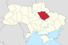
Poltava Oblast
|
Poltava Oblast Полтавська область Poltavs’ka oblast’ |
|||
|---|---|---|---|
| Oblast | |||
|
|||
| Nickname(s): Полтавщина (Poltavshchyna) | |||
 |
|||
| Country |
|
||
| Administrative center | Poltava | ||
| Government | |||
| • Governor | Valeriy Holovko (Batkivshchyna) | ||
| • Oblast council | ? seats | ||
| Area | |||
| • Total | 28,748 km2 (11,100 sq mi) | ||
| Area rank | Ranked 6th | ||
| Population (2006) | |||
| • Total | 1,544,085 | ||
| • Rank | Ranked 12th | ||
| • Density | 54/km2 (140/sq mi) | ||
| Time zone | EET (UTC+2) | ||
| • Summer (DST) | EEST (UTC+3) | ||
| Postal code | 36000-38999 | ||
| Area code | +380-53 | ||
| ISO 3166 code | UA-53 | ||
| Raions | 25 | ||
| Cities (total) | 15 | ||
| • Regional cities | 5 | ||
| Urban-type settlements | 21 | ||
| Villages | 1831 | ||
| FIPS 10-4 | UP18 | ||
| Website | www.oblrada.pl.ua/ | ||
Poltava Oblast (Ukrainian: Полтавська область, translit. Poltavs’ka oblast’; also referred to as Poltavshchyna – Ukrainian: Полтавщина) is an oblast (province) of central Ukraine. The administrative center of the oblast is the city of Poltava. Most of its territory is part of the historic Cossack Hetmanate (its southern regions: Poltava, Myrhorod, Lubny, and Hadiach).
Among other important cities, there are Horishni Plavni and Kremenchuk.
Poltava Oblast is situated in the central part of Ukraine. Located on the left bank of Dnieper, Poltava region was part of the Cossack Hetmanate. It has an area of 28,800 km². The oblast borders upon Chernihiv, Sumy, Kharkiv, Dnipropetrovsk, Kirovohrad, Cherkasy and Kyiv regions.
The following historic-cultural sites were nominated for the Seven Wonders of Ukraine.
At 2005-05-01, its population was 1,584,446, and population density was 59 people per 1 km².
The oblast’ is a center of Ukraine's oil and natural gas industry, with many wells and pipelines situated here. There is a major oil refinery plant in the city of Kremenchuk. Important iron ore processing facilities also present. In general there are 374 large industrial organization and 618 small industrial organizations.
...
Wikipedia


