Kolsky District
| Kolsky District Кольский район (Russian) |
|
|---|---|
 Location of Kolsky District in Murmansk Oblast |
|
| Coordinates: 68°53′N 33°03′E / 68.883°N 33.050°ECoordinates: 68°53′N 33°03′E / 68.883°N 33.050°E | |
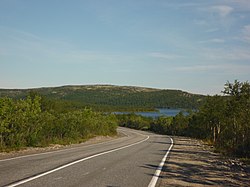
 Landscape in Kolsky District |
|
|
|
|
| Holiday | August 1 |
| Location | |
| Country | Russia |
| Federal subject | Murmansk Oblast |
| Administrative structure (as of March 2013) | |
| Administrative center | town of Kola |
| Administrative divisions: | |
| Towns | 1 |
| Urban-type settlements | 5 |
| Territorial okrugs | 5 |
| Inhabited localities: | |
| Cities/towns | 1 |
| Urban-type settlements | 5 |
| Rural localities | 26 |
| Municipal structure (as of April 2013) | |
| Municipally incorporated as | Kolsky Municipal District |
| Municipal divisions: | |
| Urban settlements | 6 |
| Rural settlements | 5 |
| Local government: | |
| Head | Mikhail Chekrygin |
| Representative body | Council of Deputies |
| Statistics | |
| Area | 27,600 km2 (10,700 sq mi) |
| Population (2010 Census) | 44,670 inhabitants |
| • Urban | 76.4% |
| • Rural | 23.6% |
| Density | 1.62/km2 (4.2/sq mi) |
| Time zone | MSK (UTC+03:00) |
| Established | August 1, 1927 |
| Previous names | Kolsko-Loparsky District (until June 1, 1936) |
| Official website | |
| on | |
Kolsky District (Russian: Ко́льский райо́н) is an administrative district (raion), one of the six in Murmansk Oblast, Russia. As a municipal division, it is incorporated as Kolsky Municipal District. It is located in the northwest of the oblast, partially lies on the Kola Peninsula, and borders with the Barents Sea in the north and Finland in the west. The area of the district is 27,600 square kilometers (10,700 sq mi). Its administrative center is the town of Kola. Population: 44,670 (2010 Census);51,125 (2002 Census);73,555 (1989 Census). The population of Kola accounts for 23.4% of the district's total population.
Kolsky District is bordered on the west by Pechengsky District, on the southwest by Finland, and on the north by the Barents Sea. The terrain is mostly flat forest (taiga) and rocky tundra. The district mostly covers the Tuloma River and the Kola River, which flow north into Kola Bay and the Barents Sea. The Tuloma River flows out of Lake Notozero, which in turn is fed from the southwest by the Nota River and the Lutto (river).
...
Wikipedia

