Kola Peninsula
| Кольский полуостров | |
|---|---|

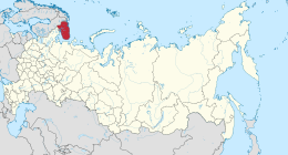
Kola Peninsula as a part of Murmansk Oblast
|
|
| Location of Murmansk Oblast within Russia | |
| Geography | |
| Location | Far Northwest |
| Coordinates | 67°41′18″N 35°56′38″E / 67.68833°N 35.94389°ECoordinates: 67°41′18″N 35°56′38″E / 67.68833°N 35.94389°E |
| Adjacent bodies of water | |
| Area | 100,000 km2 (39,000 sq mi) |
| Length | 370 km (230 mi) |
| Width | 244 km (151.6 mi) |
| Highest elevation | 1,191 m (3,907 ft) |
| Highest point | Mount Chasnachorr |
| Administration | |
|
Russia
|
|
| Oblast | Murmansk Oblast |
The Kola Peninsula (Russian: Ко́льский полуо́стров, Kolsky poluostrov; from Kildin Sami: Куэлнэгк нёаррк, Kuelnegk njoarrk; Northern Sami: Guoládatnjárga; Finnish: Kuolan niemimaa; Norwegian: Kolahalvøya) is a peninsula in the far northwest of Russia. Constituting the bulk of the territory of Murmansk Oblast, it lies almost completely inside the Arctic Circle and is bordered by the Barents Sea in the north and the White Sea in the east and southeast. The city of Murmansk is the most populous human settlement on the peninsula, with a population of over 300,000 as of the 2010 Census.
Despite the peninsula's northerly location, its proximity to the Gulf Stream leads to unusually high temperatures in winter, but also results in high winds due to the temperature variations between land and the Barents Sea. Summers are rather chilly, with the average July temperature of only 11 °C (52 °F). The peninsula is covered by taiga in the south and tundra in the north, where permafrost limits the growth of the trees resulting in landscape dominated by shrubs and grasses. The peninsula supports a small variety of mammals, and its rivers are an important habitat for the Atlantic salmon. The Kandalaksha Nature Reserve, established to protect the population of common eider, is located in the Kandalaksha Gulf.
...
Wikipedia

