Kolari
| Kolari | ||
|---|---|---|
| Municipality | ||
| Kolarin kunta | ||

Lake Kesänki at Ylläs
|
||
|
||
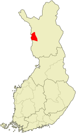
 Location of Kolari in Finland |
||
| Coordinates: 67°19′50″N 023°46′40″E / 67.33056°N 23.77778°ECoordinates: 67°19′50″N 023°46′40″E / 67.33056°N 23.77778°E | ||
| Country |
|
|
| Region | Lapland | |
| Sub-region | Fell Lapland sub-region | |
| Charter | 1867 | |
| Government | ||
| • Municipal manager | Heikki Havanka | |
| Area (2016-01-01) | ||
| • Total | 2,559.03 km2 (988.05 sq mi) | |
| • Land | 2,558.61 km2 (987.88 sq mi) | |
| • Water | 59.15 km2 (22.84 sq mi) | |
| Area rank | 21st largest in Finland | |
| Population (2016-03-31) | ||
| • Total | 3,853 | |
| • Rank | 204th largest in Finland | |
| • Density | 1.51/km2 (3.9/sq mi) | |
| Population by native language | ||
| • Finnish | 98.5% (official) | |
| • Swedish | 0.7% | |
| • Sami | 0.1% | |
| • Others | 0.8% | |
| Population by age | ||
| • 0 to 14 | 13.1% | |
| • 15 to 64 | 66.6% | |
| • 65 or older | 20.2% | |
| Time zone | EET (UTC+2) | |
| • Summer (DST) | EEST (UTC+3) | |
| Municipal tax rate | 20% | |
| Website | www.kolari.fi | |
Kolari is a municipality of Finland at the Swedish border, which follows the Torne River, the longest free-flowing river in Europe.
It is located in the province of Lapland. The municipality has a population of 3,853 (31 March 2016) and covers an area of 2,559.03 square kilometres (988.05 sq mi) of which 59.15 km2 (22.84 sq mi) is water. The population density is 1.51 inhabitants per square kilometre (3.9/sq mi). Kolari railway station is the northernmost station in Finland.
The municipality is unilingually Finnish.
Ylläs, one of the most popular ski resorts in Finland, is located in Kolari. The area also features the country's largest bog with a thousand-year-old forest.
...
Wikipedia

