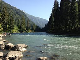
Kishanganga River
| Neelum River دریائے نیلم Krishanganga River कृष्णगंगा नदी |
|
| River | |
|
Neelum River
|
|
| Region | Kashmir |
|---|---|
| Tributaries | |
| - left | Sind River, Lidder River |
| Source | 34°23′23″N 75°07′19″E / 34.389629°N 75.121806°ECoordinates: 34°23′23″N 75°07′19″E / 34.389629°N 75.121806°E |
| - location | Krishansar Lake at Sonamarg, India |
| - elevation | 3,710 m (12,172 ft) |
| Mouth | 34°21′18″N 73°28′07″E / 34.354869°N 73.468537°E |
| - location | Jehlum River at Muzaffarabad, Pakistan |
| - elevation | 750 m (2,461 ft) |
| Length | 245 km (152 mi) |
| Discharge | |
| - average | 465 m3/s (16,421 cu ft/s) |
The Neelum River (Hindi: नीलम नदी, Urdu: دریائے نیلم), or Kishanganga (Sanskrit/Hindi: कृष्णगंगा नदी, Urdu: کرشن گنگا ندی), is a river in the Kashmir region of India and Pakistan; it starts in the Indian city of Gurais and then merges with the Jhelum River near the Pakistani city of Muzaffarabad.
The Neelam River originates from Krishansar Lake in the vicinity of Sonamarg and runs northwards to Badoab village where it meets a tributary from the Dras side and runs westwards along the Line of Control in Jammu and Kashmir. It is fed by many glacial tributary streams on its way. It enters Azad Kashmir in the Gurez sector of the Line of Control, and then runs west until it meets the Jhelum River in Muzaffarabad. The Neelum River is 245 kilometers long, it covers 50 kilometers in Jammu and Kashmir and the remaining 195 kilometers in Pakistan-administered Kashmir.
...
Wikipedia

