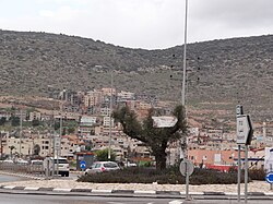
Kfar Manda
Kafr Manda
|
|
|---|---|
| Hebrew transcription(s) | |
| • ISO 259 | Kpar Mandaˀ |
| • Also spelled | Kafar Manda (official) Kfar Manda, Kufur Manda (unofficial) |
 |
|
| Coordinates: 32°49′N 35°16′E / 32.817°N 35.267°ECoordinates: 32°49′N 35°16′E / 32.817°N 35.267°E | |
| Grid position | 174/246 PAL |
| District | Northern |
| Government | |
| • Type | Local council (from 1973) |
| Area | |
| • Total | 11,052 dunams (11.052 km2 or 4.267 sq mi) |
| Population (2015) | |
| • Total | 18,509 |
| Name meaning | The village of Menda |
Kafr Manda or Kfar Menda (Arabic: كفر مندا, Hebrew: כַּפְר מַנְדָא) is an Arab town in the Lower Galilee on the slopes of Mount Atzmon in Israel's Northern District. Kafr Manda is 16 kilometres (9.9 mi) northwest of the city of Nazareth. In 2015 its population was 18,509. The inhabitants are predominantly Arab Muslims.
The village is located on an ancient site on a low hill. Ancient relics have been found, including architectural fragments, two fragmentary columns and capitals. Some remains from the Roman and Byzantine era have been found.
According to the 13th century Muslim scholar Yaqut al-Hamawi,
Kafr Manda lies between Acre and Tiberias and also goes by the name Midian. The tomb of the wife of Moses is seen here. Also, the pit covered by the rock which Moses raised up in order give himself and his wife water to drink... At Kafr Mandah may also be seen the tombs of two of Jacob's sons Asher and Naphthali as is reported.
In 1962, “hundreds of clay jars, some of which were intact” dating to the 14th–15th centuries were found. Other remains from the Mamluk era have also been excavated.
...
Wikipedia

