Kenting
| Kenting National Park | |
|---|---|
|
IUCN category II (national park)
|
|

Cape Maobitou in Kenting National Park
|
|
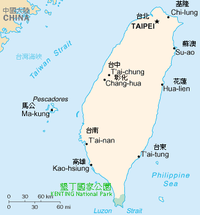
| Location of Kenting National Park in Taiwan | |
| Location | Taiwan |
| Nearest city | Hengchun |
| Coordinates | 21°58′48″N 120°47′49″E / 21.98°N 120.797°ECoordinates: 21°58′48″N 120°47′49″E / 21.98°N 120.797°E |
| Area | 333 km2 (129 sq mi) |
| Established | 1 January 1984 |
| Visitors | 8,376,708 (in 2014) |
| Governing body | Kenting National Park Administration Office |
| http://www.ktnp.gov.tw/eng/ | |
| Kenting National Park | |||||||||||||
| Traditional Chinese | |||||||||||||
|---|---|---|---|---|---|---|---|---|---|---|---|---|---|
| Simplified Chinese | |||||||||||||
|
|||||||||||||
| Transcriptions | |
|---|---|
| Standard Mandarin | |
| Hanyu Pinyin | Kěndīng Gúojiā Gōngyuán |
| Wade–Giles | K'en3-ting1 Kuo2-chia1 Kung1-yüan2 |
| Southern Min | |
| Hokkien POJ | Khún-teng kok-ka kong-hn̂g |
The Kenting National Park (Chinese: 墾丁國家公園; pinyin: Kěndīng Gúojiā Gōngyuán), commonly known as Kenting (Chinese: 墾丁; pinyin: Kěndīng), is a national park located in the Hengchun Peninsula of Pingtung County, Taiwan, covering Hengchun, Checheng, and Manzhou Townships. Established on January 1, 1984, it is Taiwan's oldest and southernmost national park, covering the southernmost area of the Taiwan island along Bashi Channel. Administered by the Executive Yuan's Ministry of the Interior, this national park is well known for its tropical climate and sunshine, scenic mountain and beach, the Spring Scream rock-band festival held in every March, and has long been one of the most popular tourist destinations in Taiwan.
The park covers about 181 square kilometres (70 sq mi) of land, 152 square kilometres (59 sq mi) of sea, weighing in at 333 square kilometres (129 sq mi) combined. Nan Wan and Banana Bay (香蕉灣) is surrounded by the Pacific Ocean, the Taiwan Strait, and the Luzon Strait. The park is 90 kilometres (56 mi) away from Kaohsiung, 140 kilometres (87 mi) away from Tainan.
The landscape boasted by Kenting National Park is divided into two parts by the long and narrow Hengchun Longitudinal Valley Plain that extends from north to south. With coral sea cliffs teemed with fringing reefs along the west coast, the park features a large number of mountains in the north, and coral tablelands and foothills in the south. The plain, which is formed by fault valleys, has a vast lake called Longlyuantan, together with rising coral tablelands and limestone caves to the east. The east side of the coral tablelands features unique sand rivers and sand waterfalls formed by the combined effects of winds and rivers, as well as coral cliffs, sunken caves and stalactites.
...
Wikipedia

