Kampinos National Park
| Kampinos National Park | |
|---|---|
| Kampinoski Park Narodowy | |
|
IUCN category II (national park)
|
|

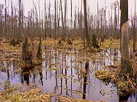
Swamps in Kampinos Forest
|
|
| Park logo with Moose | |
| Location | Masovian Voivodeship, Poland |
| Area | 385.44 km² |
| Established | 1959 |
| Governing body | Ministry of the Environment |
Kampinos National Park (Polish: Kampinoski Park Narodowy) is a National Park in east-central Poland, in Masovian Voivodeship, on the north-west outskirts of Warsaw. It has a sister park agreement with Indiana Dunes National Lakeshore, Indiana, United States.
The idea of creating a park here appeared for the first time in the 1920s. In the 1930s the first forest reserves were opened: Granica, Sieraków and Zamczysko. Today, these reserves are much larger and are strictly protected.
The park was created in 1959, covering a total area of 407 square kilometres (157 sq mi). It covers the ancient Kampinos Forest (Puszcza Kampinoska), and in January 2000 the area was added to UNESCO’s list of biosphere reserves. The Park is now slightly smaller than originally, covering 385.44 square kilometres (148.82 sq mi), of which 46.38 km² is strictly protected. The protective zone around the Park covers 377.56 km². Forests account for around 70% of the park’s area, and most the common tree is the pine. The Park’s symbol is the moose.
Kampinoski National Park is located at the biggest river junction in Poland - here valleys of Vistula, Bug, Narew, Wkra and Bzura meet together. There are no lakes, the biggest river of the Park is the Łasica, a tributary to the Bzura, which acts as a water canal.
Park’s flora is rich with around 1245 species of plants, of which 69 are protected. Park’s landscape is a mix of sand dunes and swamp lands with pine trees growing on sand and meadows on swamps.
...
Wikipedia

