Jackson County, Missouri
| Jackson County, Missouri | |
|---|---|

Jackson County Courthouse in Independence, designed by Edward F. Neild at the request of Harry S. Truman
|
|
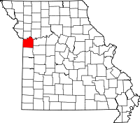
 Location in the U.S. state of Missouri |
|
 Missouri's location in the U.S. |
|
| Founded | December 15, 1826 |
| Named for | President Andrew Jackson |
| Seat | Independence and Kansas City |
| Largest city | Kansas City |
| Area | |
| • Total | 616 sq mi (1,595 km2) |
| • Land | 604 sq mi (1,564 km2) |
| • Water | 12 sq mi (31 km2), 1.9% |
| Population (est.) | |
| • (2015) | 687,623 |
| • Density | 1,115/sq mi (431/km²) |
| Congressional districts | 5th, 6th |
| Time zone | Central: UTC-6/-5 |
| Website | www |
Jackson County is a county located in the western portion of the U.S. state of Missouri. As of the 2010 census, the population was 674,158. making it the second-most populous county in the state (after St. Louis County). Although Independence retains its status as the original county seat, Kansas City serves as a second county seat and the center of county government. The county was organized December 15, 1826 and named for President Andrew Jackson (elected 1828).
Jackson County is the central county of the Kansas City, MO-KS Metropolitan Statistical Area.
Jackson County was home to members of the Osage Native American tribe. The first known European explorers were French trappers who used the Missouri River as a highway for explorations and trading with Native American tribes. Jackson County was a part of New France, until the British victory in the French and Indian War in 1763 resulted in the cession of this territory to Great Britain's ally, Spain. Spain was forced by the Third Treaty of San Ildefonso in 1800 to return its Louisiana Territory (of which modern Jackson County then formed a part) to France, which in turn sold it to the United States in the Louisiana Purchase of 1803.
...
Wikipedia
