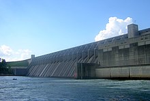
J. Strom Thurmond Dam
| J. Strom Thurmond Dam | |
|---|---|

J. Strom Thurmond Dam
|
|
| Location |
|
| Coordinates | 33°39′39″N 82°11′59″W / 33.66083°N 82.19972°WCoordinates: 33°39′39″N 82°11′59″W / 33.66083°N 82.19972°W |
| Construction began | 1946 |
| Opening date | 1954 |
| Construction cost | $78.5 million |
| Operator(s) | U.S. Army Corps of Engineers |
| Dam and spillways | |
| Impounds | Savannah River |
| Height | 200 feet (61 m) (thalweg) |
| Length | 1 mile (1.73 km) |
| Reservoir | |
| Creates | Lake Strom Thurmond |
| Catchment area | 6,144 sq mi (15,910 km2) |
| Surface area | 71,100 acres (28,800 ha) |
| Power station | |
| Turbines | 7 |
| Installed capacity | 380 MW |
| Annual generation | 700,000,000 KWh annually |
J. Strom Thurmond Dam, also known in Georgia as Clarks Hill Dam, is a concrete-gravity and embankment dam located 22 miles (35 km) north of Augusta, Georgia on the Savannah River at the border of South Carolina and Georgia, creating Lake Strom Thurmond. U.S. Route 221 (and Georgia State Route 150 on the Georgia side of the state line) cross it. The dam was built by the U.S. Army Corps of Engineers between 1946 and 1954 for the purposes of flood control, hydroelectricity and downstream navigation. The concrete structure of the dam spans 1,096 feet (334 m) and rises 204 feet (62 m) above the riverbed, housing a power plant with an installed 380 MW capacity. The Dam has prevented over $185,000 in estimated flood damage annually and also provides recreation, water quality, water supply, along with fish and wildlife management.
Since 1988, the official name of the dam is after Strom Thurmond, a longtime Senator. Originally and accepted in Georgia, the dam is named after revolutionary war hero, Elijah Clark, who is also buried on the western banks of the lake on acreage that is now Elijah Clark State Park and Recreation Area.
In 1890, Lieutenant Oberlin M. Carter of the U.S. Army Corps of Engineers (USACE) Savannah Office issued a survey report that recommended the construction of dams on the Savannah River in order to prevent flooding in Augusta, Georgia. His report was overlooked until the 1927 Rivers and Harbors Act allowed the USACE to investigate development of the Savannah River for the purpose of hydroelectricity, navigation, flood control and irrigation. In 1933, the USACE completed the report for the entire Savannah River Basin that recommended against government flood control development of the basin but did propose two hydropower dams in the upper Savannah Basin, the Clark Hill and Hartwell Dams.
...
Wikipedia
