Interstate 40 in North Carolina
| Interstate 40 | ||||
|---|---|---|---|---|
 |
||||
| Route information | ||||
| Maintained by NCDOT | ||||
| Length: | 423.55 mi (681.64 km) | |||
| Existed: | 1958 – present | |||
| Major junctions | ||||
| West end: |
|
|||
| East end: |
|
|||
| Location | ||||
| Counties: | Haywood, Buncombe, McDowell, Burke, Catawba, Iredell, Davie, Forsyth, Guilford, Alamance, Orange, Durham, Wake, Johnston, Sampson, Duplin, Pender, New Hanover | |||
| Highway system | ||||
|
||||
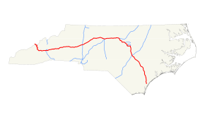
Interstate 40 (I-40) is a part of the Interstate Highway System that runs from Barstow, California to Wilmington, North Carolina. In North Carolina, I-40 enters the state along the Pigeon River Gorge, from Tennessee. Crossing the entire state, it connects the cities of Asheville, Winston-Salem, Greensboro, Durham and Raleigh before ending along U.S. Highway 117/North Carolina Highway 132 (US 117/NC 132) in Wilmington. The landscapes traversed by I-40 include the Blue Ridge Mountains, foothills of western North Carolina, suburban communities, the urban core of several Piedmont cities, along with eastern North Carolina farmland. At a total of 423.55 miles (681.64 km), it is the longest interstate highway in North Carolina. There are five auxiliary Interstates in the state related to I-40, as well as one business loop which currently runs through Winston-Salem. The route is labeled east-west for the entire route (as are all even-numbered Interstate highways), however the eastern portion (from Hillsboro to Wilmington) follows a much more north-south alignment.
...
Wikipedia

