New Hanover County, North Carolina
| New Hanover County, North Carolina | ||
|---|---|---|

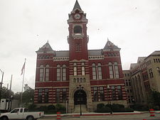
New Hanover County Courthouse in Wilmington
|
||
|
||
 Location in the U.S. state of North Carolina |
||
 North Carolina's location in the U.S. |
||
| Founded | 1739 | |
| Named for | House of Hanover | |
| Seat | Wilmington | |
| Largest city | Wilmington | |
| Area | ||
| • Total | 328 sq mi (850 km2) | |
| • Land | 192 sq mi (497 km2) | |
| • Water | 137 sq mi (355 km2), 42% | |
| Population | ||
| • (2010) | 202,667 | |
| • Density | 1,058/sq mi (408/km²) | |
| Congressional districts | 3rd, 7th | |
| Time zone | Eastern: UTC-5/-4 | |
| Website | www |
|
New Hanover County is one of 100 counties located in the U.S. state of North Carolina. As of the 2010 census, the population was 202,667. Though second smallest in area, it is one of the most populous as its county seat, Wilmington, is one of the state's largest cities. The county was created in 1729 as New Hanover Precinct and gained county status in 1739.
New Hanover County is included in the Wilmington, NC Metropolitan Statistical Area, which also includes neighboring Pender county.
The county was formed in 1729 as New Hanover Precinct of Bath County, from Craven Precinct. It was named for the House of Hanover, a German noble family which was then ruling Great Britain.
In 1734 parts of New Hanover Precinct became Bladen Precinct and Onslow Precinct. With the abolition of Bath County in 1739, all of its constituent precincts became counties.
In 1750 the northern part of New Hanover County became Duplin County. In 1764 another part of New Hanover County was combined with part of Bladen County to form Brunswick County. Finally, in 1875 the separation of northern New Hanover County to form Pender County reduced it to its present dimensions.
Alfred Eichberg designed the New Hanover County Courthouse.
...
Wikipedia

