Johnston County, North Carolina
| Johnston County, North Carolina | ||
|---|---|---|
| County | ||
| County of Johnston | ||

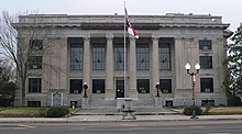
Johnston County Courthouse in Smithfield
|
||
|
||
 Location in the U.S. state of North Carolina |
||
 North Carolina's location in the U.S. |
||
| Founded | June 28, 1746 | |
| Named for | Gabriel Johnston | |
| Seat | Smithfield | |
| Largest town | Clayton | |
| Area | ||
| • Total | 796 sq mi (2,062 km2) | |
| • Land | 791 sq mi (2,049 km2) | |
| • Water | 4.2 sq mi (11 km2), 0.5% | |
| Population (est.) | ||
| • (2014) | 181,423 | |
| • Density | 229.4/sq mi (89/km²) | |
| ZIP code(s) | 27501, 27504, 27520, 27524, 27527, 27529, 27542, 27555, 27557, 27568, 27569, 27576, 27577, 27591, 27592, 27597, 27603, 28334, 28366 | |
| Area code(s) | 919, 984 | |
| Congressional district | 7th | |
| Time zone | Eastern: UTC-5/-4 | |
| Website | www |
|
Johnston County is a county located in the U.S. state of North Carolina. As of the 2010 census, the population was 168,878. Its county seat is Smithfield.
Johnston County is included in the Raleigh, NC Metropolitan Statistical Area, which is also included in the Raleigh-Durham-Chapel Hill, NC Combined Statistical Area, which has a population of 1,998,808 as of U.S. Census 2012 Population Estimates.
The county was formed in 1746 from Craven County. It was named for Gabriel Johnston, Governor of North Carolina from 1734 to 1752. In 1752 parts of Johnston County, Bladen County, and Granville County were combined to form Orange County. In 1758 the eastern part of Johnston County became Dobbs County. In 1770 parts of Johnston County, Cumberland County, and Orange County were combined to form Wake County. Finally, in 1855 parts of Johnston County, Edgecombe County, Nash County, and Wayne County were combined to form Wilson County.
...
Wikipedia

