Hurricane Richard
| Category 2 hurricane (SSHWS/NWS) | |

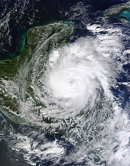
Richard as a Category 1 hurricane off the Belizean coast on October 24
|
|
| Formed | October 20, 2010 |
|---|---|
| Dissipated | October 27, 2010 |
| (Remnant low after October 25) | |
| Highest winds |
1-minute sustained: 100 mph (155 km/h) |
| Lowest pressure | 977 mbar (hPa); 28.85 inHg |
| Fatalities | 1 direct, 1 indirect |
| Damage | $80 million (2010 USD) |
| Areas affected | Honduras, Belize, Guatemala and Mexico |
| Part of the 2010 Atlantic hurricane season | |
Hurricane Richard was a damaging hurricane that affected areas of Central America in October 2010. It developed on October 20 from an area of low pressure that had stalled in the Caribbean Sea. The system moved to the southeast before turning to the west. The storm slowly organized, and the system intensified into a tropical storm. Initially, Richard only intensified slowly in an area of week steering currents. However, by October 23, wind shear diminished, and the storm intensified faster as it headed toward Belize. The next day, Richard intensified into hurricane status, and further into its peak intensity as a Category 2 hurricane, reaching maximum winds of 100 mph (150 km/h). The hurricane made its only landfall on Belize at peak intensity. Over land, Richard quickly weakened, and later degenerated into a remnant low on October 25.
Hurricane Richard caused an estimated $80 million (2010 USD) in damages in its path, much of which was in Belize. In Honduras, damage was mostly limited to power outages and landslides. In Belize, most of the damage was attributed to damage to crops. Power outages were also widespread across the country. Two fatalities occurred in Belize, one direct and the other indirect. One person drowned after his ship capsized during the storm and another was mauled to death by a jaguar that had escaped its cage.
The origins of Hurricane Richard can be traced back to a tropical wave that moved off the African coast on October 4 and moved westward, stalling over Venezuela on October 13. Over the next 3 days, it drifted into the extreme southwestern Caribbean Sea, and soon developed an area of low pressure, until it stalled just north of Panama. On October 16, the National Hurricane Center (NHC) began to monitor that area of disturbed weather in association with a weak trough of low pressure over the southwestern Caribbean Sea, which persisted across the region as Hurricane Paula dissipated over Cuba on the same day. By October 17, the easterly and northerly trade winds flowed into the low, producing a disorganized area of convection, or thunderstorms across the region. For several days the system moved generally west-northwestward toward Central America. Convection increased over the low on October 18, and the National Hurricane Center noted the possibility of further organization due to favorable environmental conditions. Later that day, it passed near the eastern coast of Nicaragua. The storm became more organized as it turned to a north-northwest drift in the northwestern Caribbean Sea.
...
Wikipedia
